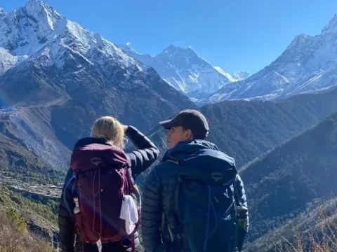
Mount Everest is often referred to as the "King of the Mountains," and for good reason. At 8,848 meters (29,032 feet), Mount Everest is the tallest mountain on the planet by a wide margin. And because of its height and well-known climbing history, it is also the most famous mountain on Earth. While a visit to the summit of Everest is too dangerous and difficult for most people, many would be surprised to learn that a visit to Everest Base Camp, which sits at a more modest 5,364 meters (17,598 ft), is within reach of most. Everest Base Camp is a magical place; a massive, mountain amphitheater overlooking a moving glacier, surrounded by peaks of more than 7,000 meters, and boasting some of the most incredible views on Earth.
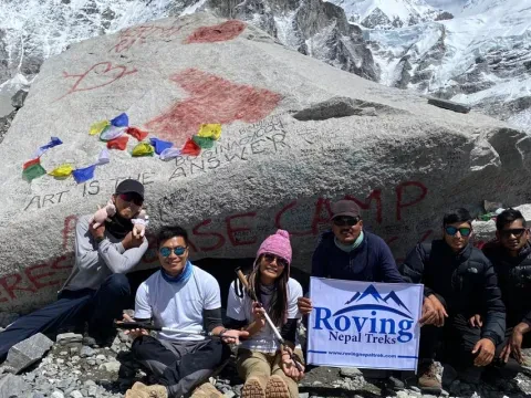
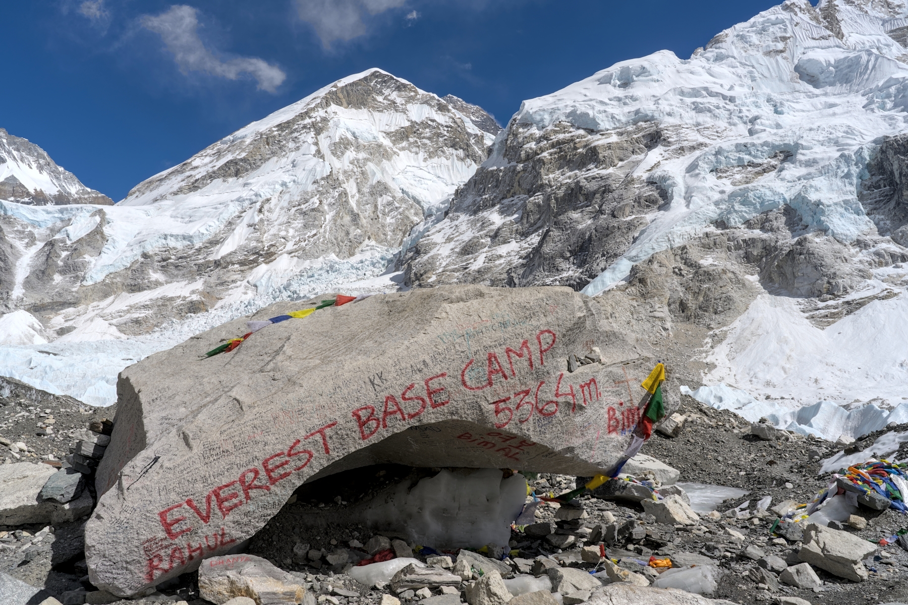 The famed Everest Base Camp rock, with Mount Everest barely visible at top center
So why is it that less than 30% of people who trek in Nepal visit Everest Base Camp? Nearly everyone on Earth has heard of Mount Everest, and yet far more people who come to Nepal see less famous mountains like Annapurna and Dhaulagiri instead. Do people think that because climbing Mount Everest is so difficult and dangerous that the trek to Everest Base Camp must be difficult as well? Are people afraid of the flight to Lukla? Have people heard that that there are other treks in Nepal that are better? Is it a mistaken belief that the EBC trek is overrated or just not as good as other treks in Nepal?
This blog post will explore the reasons why, just as "Everest is the King of the Mountains," the EBC trek is the “King of the Treks” in Nepal. But for the TL;DR (too long; didn’t read) crowd, a brief summary at the beginning might help.
More than any other trek on Earth, the EBC Trek will give you bragging rights. Sure, there are longer, more difficult, more remote, and more epic treks out there. But tell someone that you trekked Upper Dolpo, did the Kanchenjunga or Dhaulagiri Circuit, or made it to Tilicho Base Camp, and you’ll be likely met with polite stares and confused silence. Even better well-known treks like Annapurna Circuit and Langtang Valley simply aren’t well-known to the general public. But Mount Everest? Everyone knows about Mount Everest. If you tell someone you went to Nepal, the first thing they will ask is: “Did you go to Mount Everest?” I’m serious, that is ALWAYS the first question they ask. And when you tell them, “Why, yes. Yes, I did” they will inevitably be impressed.
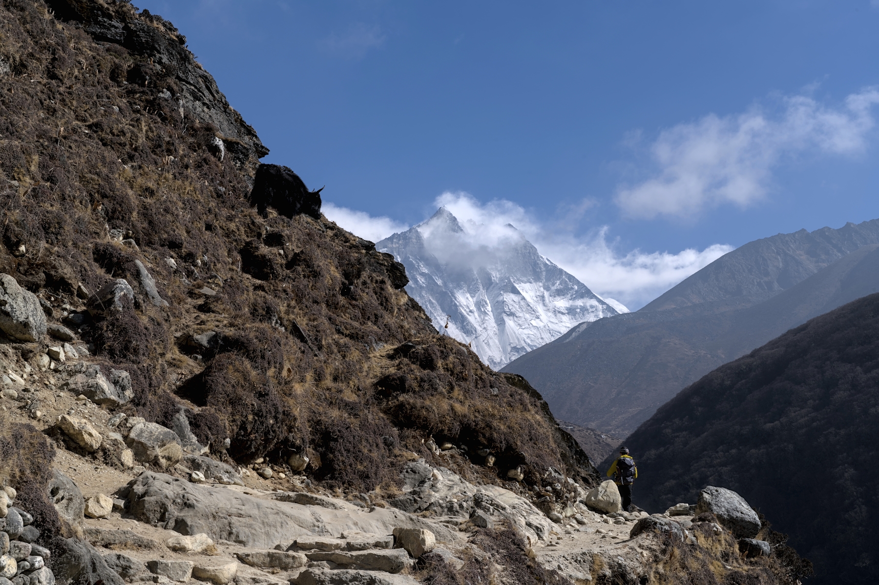
A bit of bouldering on the trail, about a half hour’s walk from EBC
The EBC trek also does a great job of striking a balance between challenging yourself and staying safe. The EBC Trek is far from the easiest trek in Nepal, but it is also by no means the most difficult. There are more difficult uphill climbs on the EBC Trek than on most treks and there is a lot of elevation gain, but other treks (such as the Annapurna Circuit) are more difficult. Aside from the Three Passes Trek (which itself is an offshoot of the EBC Trek), there isn’t a trek in Nepal that brings trekkers to such high elevations for such a long period of time. You’ll spend four nights in a row above 4,400 meters (14,436 ft), which is higher than the highest point of most countries, however the trek gains altitude steadily and gradually to allow time to acclimatize. And in case of altitude sickness, the people of this region are so experienced in dealing with altitude sickness and the helicopter rescue infrastructure is so well-established that helicopter rescues, though rare, are almost routine at this point. All told, for those interested in mountain climbing who want to see how their bodies hold up to the challenges of climbing at high altitude, the EBC Trek is one of the best and safest tests there is. 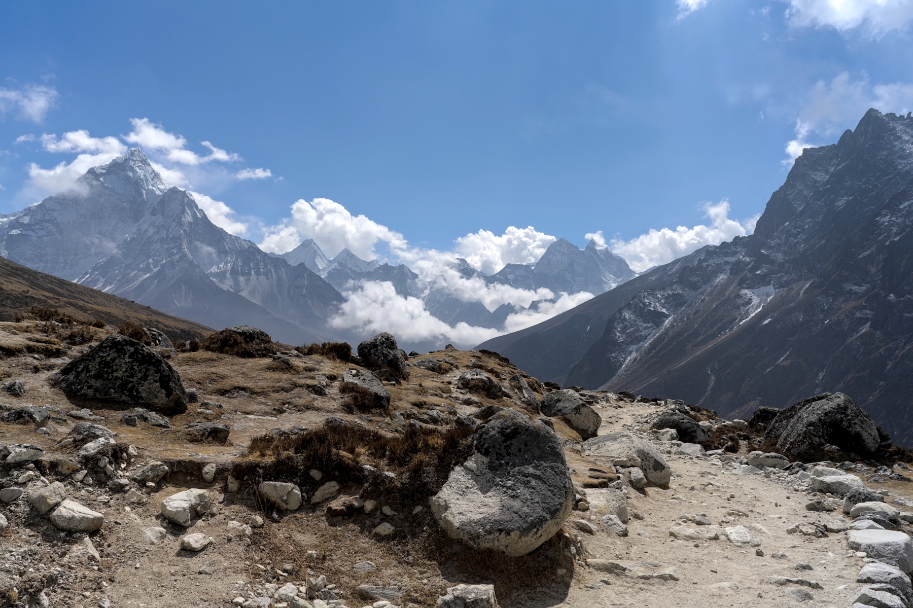
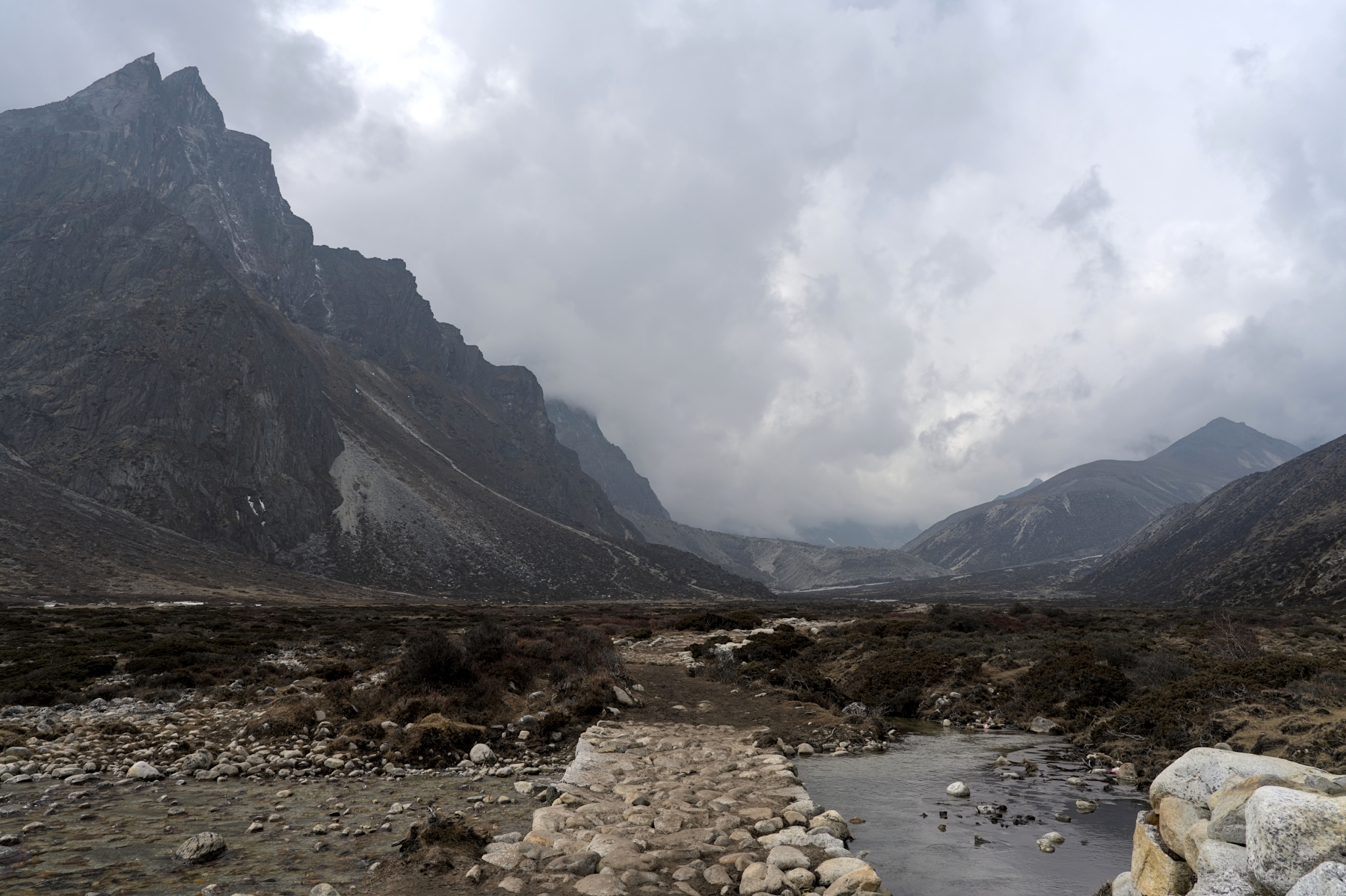
The trekking trail at the Thukla Pass, with Ama Dablam on far left
The EBC trek also represents a great balance between wild, untouched natural trekking and convenience. If constant cell phone service, fast Wi-Fi, regular hot showers, private bathrooms, and reliable electricity are import to you, maybe the Everest Region isn’t right for you. The trekking trail, especially in the upper reaches of the trek, is raw and rugged compared with the roads and well-manicured walking paths in the Annapurna Region. If you aren’t much of a hiker and just want to see some mountains and check your emails and social media regularly throughout the trek, trekking in the Annapurna Region might be better.
But isn’t trekking about connecting with nature? In the Everest Region, the lack of roads, cellular service, and many of the amenities that seem to define modern life will help you to appreciate nature for what it is. You won’t see roads, vehicles, overhead power lines, or cell phone towers for nearly two weeks. You don’t know how refreshing that is until you experience it. That said, if you’re feeling a bit too disconnected, there is usually Wi-Fi and hot showers available for purchase at the tea house, and although eating meat is a bad idea above Namche Bazar, you can eat comfort foods like pizza, macaroni and cheese, and Mars Bars throughout your trek. And every morning still starts with coffee or tea for the caffeine addicts.
View of Pumori (7,161 m) from the trail between Lobuche and Gorak Shep
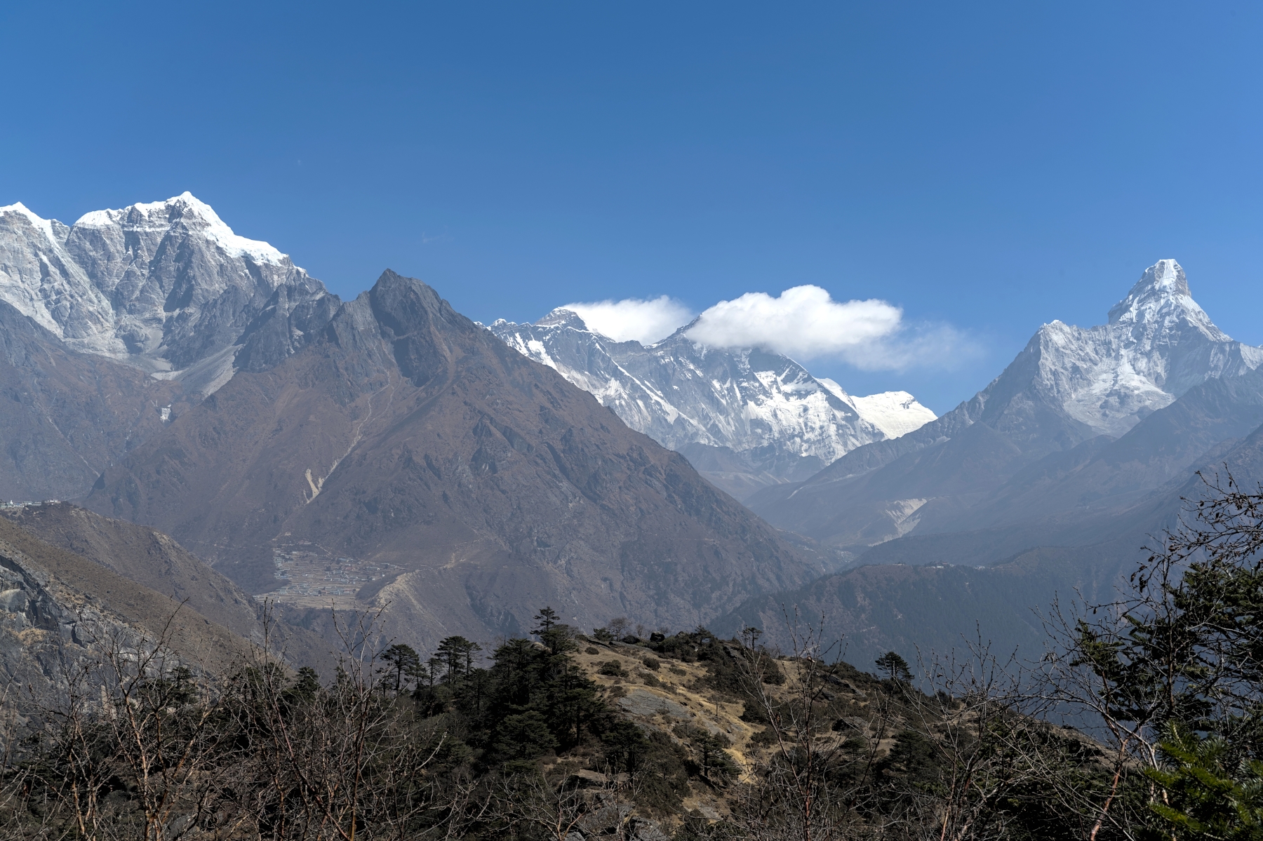
Finally, the EBC Trek has some of the best views Nepal has to offer. Seeing the Everest Massif and Ama Dablam from the Everest View Hotel while enjoying a cup of tea is guaranteed to give you one of the most satisfied smiles you'll ever have. Viewing the Dingboce Valley, with Makalu, Baruntse, Island Peak, and Lhotse glowing white in the morning sky is a view you might not have seen when researching this trek, but after seeing it, will wonder why it isn't more famous. The incredible, 360-degree views from the plateau atop the Thukla Pass will likely be the most breathtakingly beatufiul thing you've seen in your life up to that point. And that famous view from Everest Base Camp, with Lhotse, Nuptse, Changtse, Khumbutse, Lingren, Pumori, and of course Mount Everest towering above will be a view that you'll never forget.
Does this trek sound like something you'd be interested in? If so, feel free to read the more detailed, day-by-day description of the trek below.
One of the hardest parts of the Everest Base Camp Trek is getting there. Mount Everest is a part of Sagarmatha National Park (Sagarmatha is the Nepali name for Mount Everest), which is in a remote area of Nepal. Although Lukla, the starting point of the EBC trek, can be reached by road, the drive to Lukla from Kathmandu takes 20 hours in a cramped bus, driving on rough mountain roads. By contrast, the flight to Lukla takes only 30 minutes. For this reason, nearly everyone who treks in the Everest Region flies into Lukla.
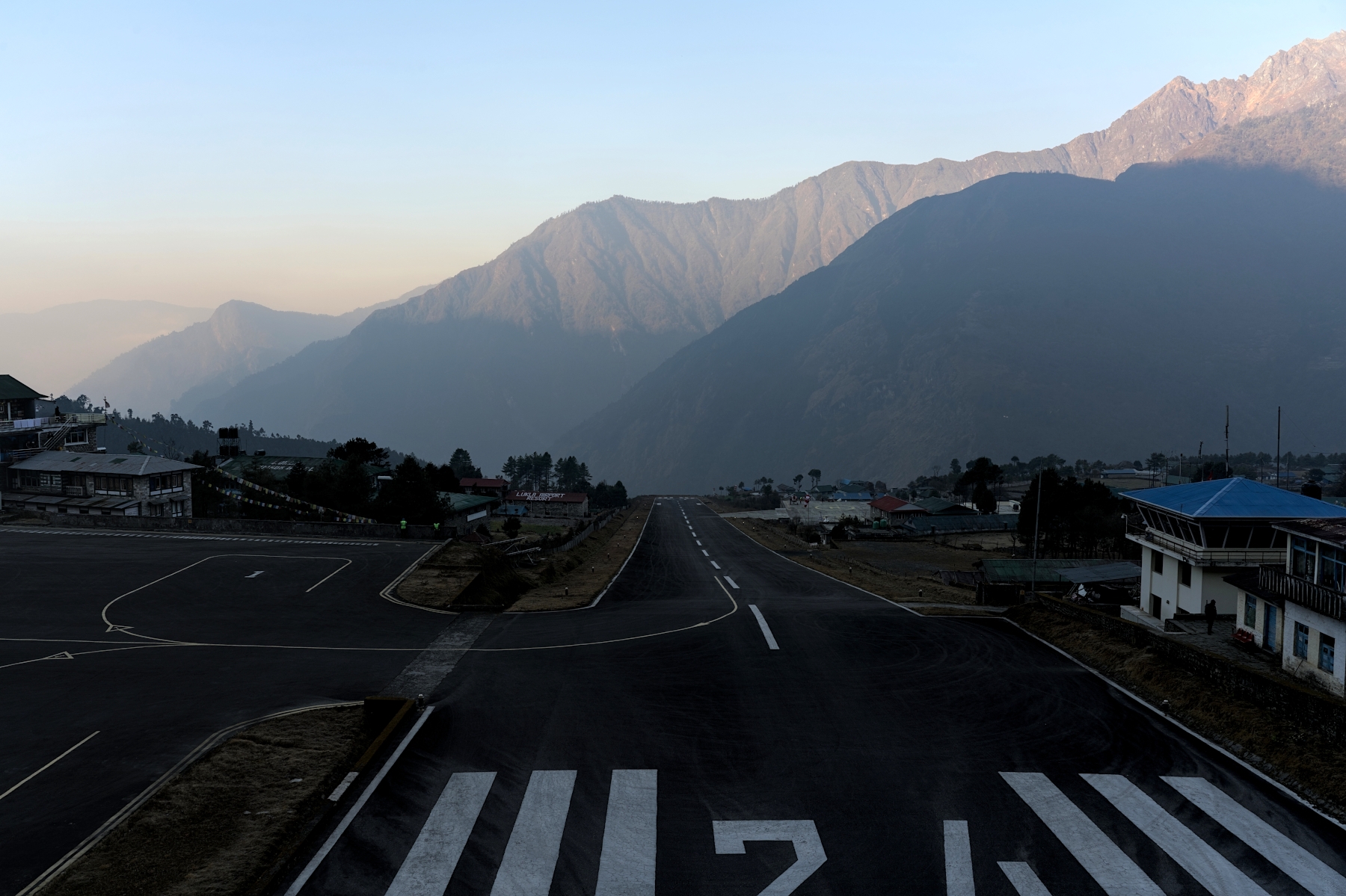
Lukla airport in morning just before the first plane departure of the day
Some travelers are hesitant to fly to Lukla because of how dangerous they’ve heard it is. Search online for "most dangerous airport on Earth” and nearly every list you'll come across will rank Tenzing-Hillary Airport in Lukla as #1. And it’s easy to understand why. This airport sits at 2,800 meters elevation and is surrounded by mountains on all sides. The runway is very short due to the surrounding terrain, with a mountain wall on one end and the edge of a cliff on the other. And although safety has improved considerably over the last decade or so, given the somewhat checkered safety record of certain Nepali airlines, this flight does present more risk than your average commercial flight. But tens of thousands of trekkers travel to the Everest Region every year with nearly all of them flying into and out of Lukla, so don’t let what you read on the internet dissuade you from doing the EBC Trek. The flight to Lukla will probably be the most beautiful flight you'll ever take, but it will DEFINITELY be the most memorable.
After the thrill of the flight wears off, you’ll find yourself in Lukla, a quaint, hillside town that serves as the gateway to the Everest Region. After a cup of coffee or tea at a local teahouse, you will set off, walking along cobblestone paths and passing countless trekking supply stores. At this point it begins to hit you: you're on your way to Everest. After leaving Lukla, the trail becomes mostly hardpack dirt, with some paved and/or stone sections, especially when going up or down. This easy-to-navigate trail meanders along hillsides, through dense Rhododendron forests and small villages, with the faint roar of the Dudh Koshi River below. This portion of the trek is relatively flat (by Nepal standards), though there are still some ups and downs. Trekkers typically stop for the day in Phakding, a small village that spans the Dudh Koshi River.
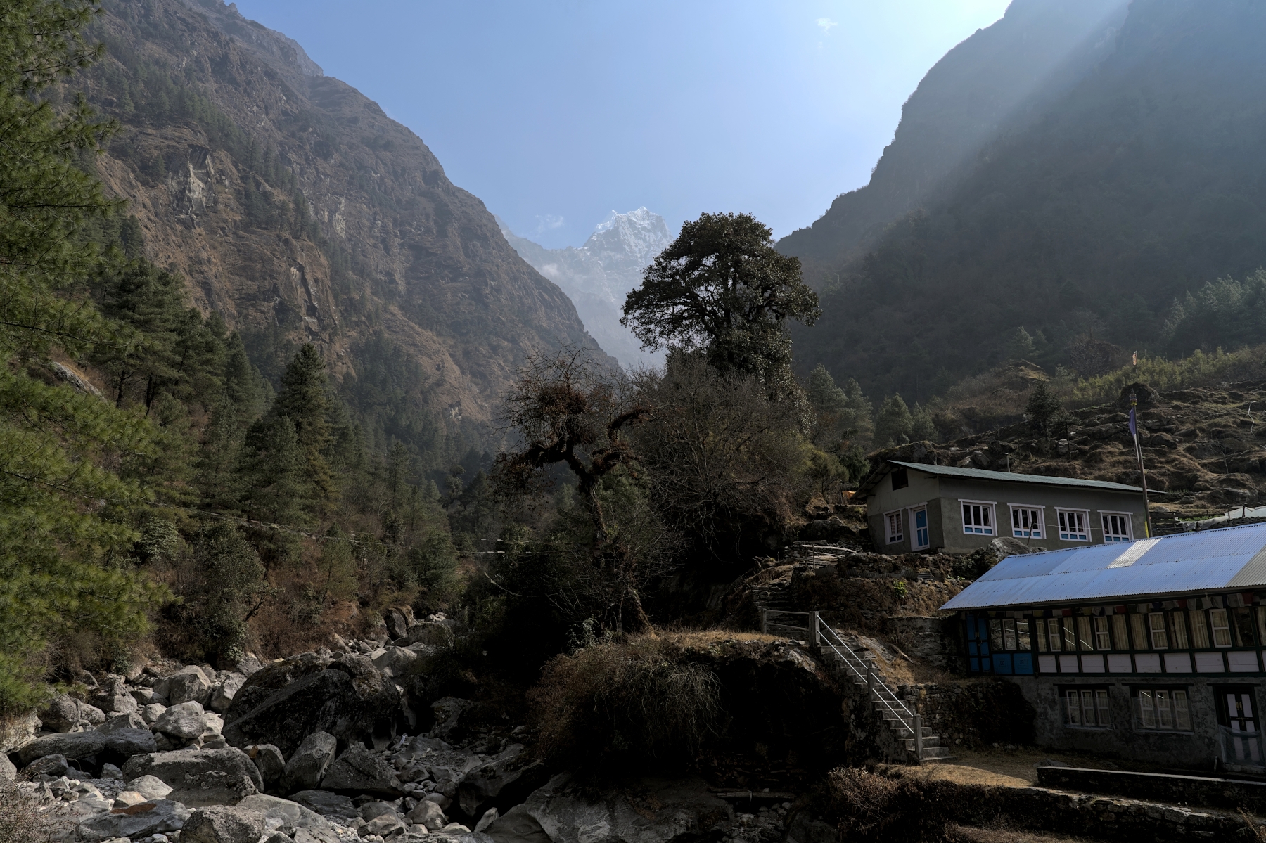
View from “Mudslide Bridge” in Chaurikharka, with Kusum Kanguru (6,367 m) in background
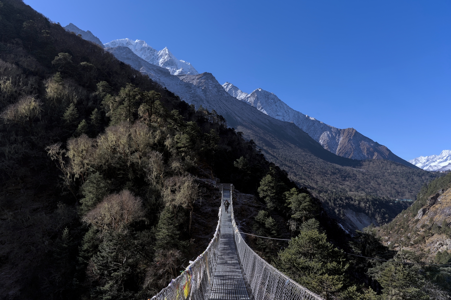
The next day the “Nepal flatness” of the trail continues along the river until the afternoon, when the first true climb of the trek begins. After crossing the famed Hillary Bridge, with stunning views of the river and surrounding hills (and even Lhotse off in the distance if the weather cooperates), the trail heads uphill towards Namche Bazaar. This section of the trail rises approximately 600 meters in a relatively short distance, making it steep and physically demanding. The trail itself consists mostly of narrow, well-maintained, dirt covered switchbacks. Around halfway up this hill section there will be a small clearing where, in good weather, you will get your first glimpse of Mount Everest.
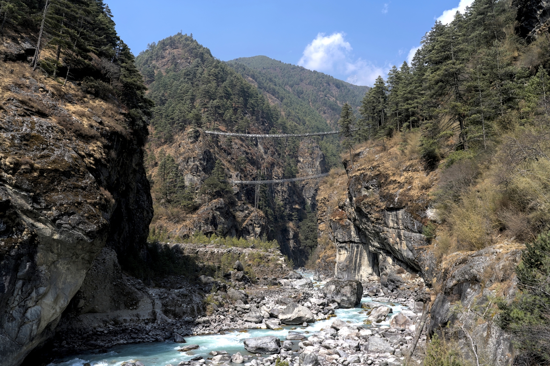
The new Hillary Bridge (top) and old Hillary Bridge (bottom) taken from the riverside below
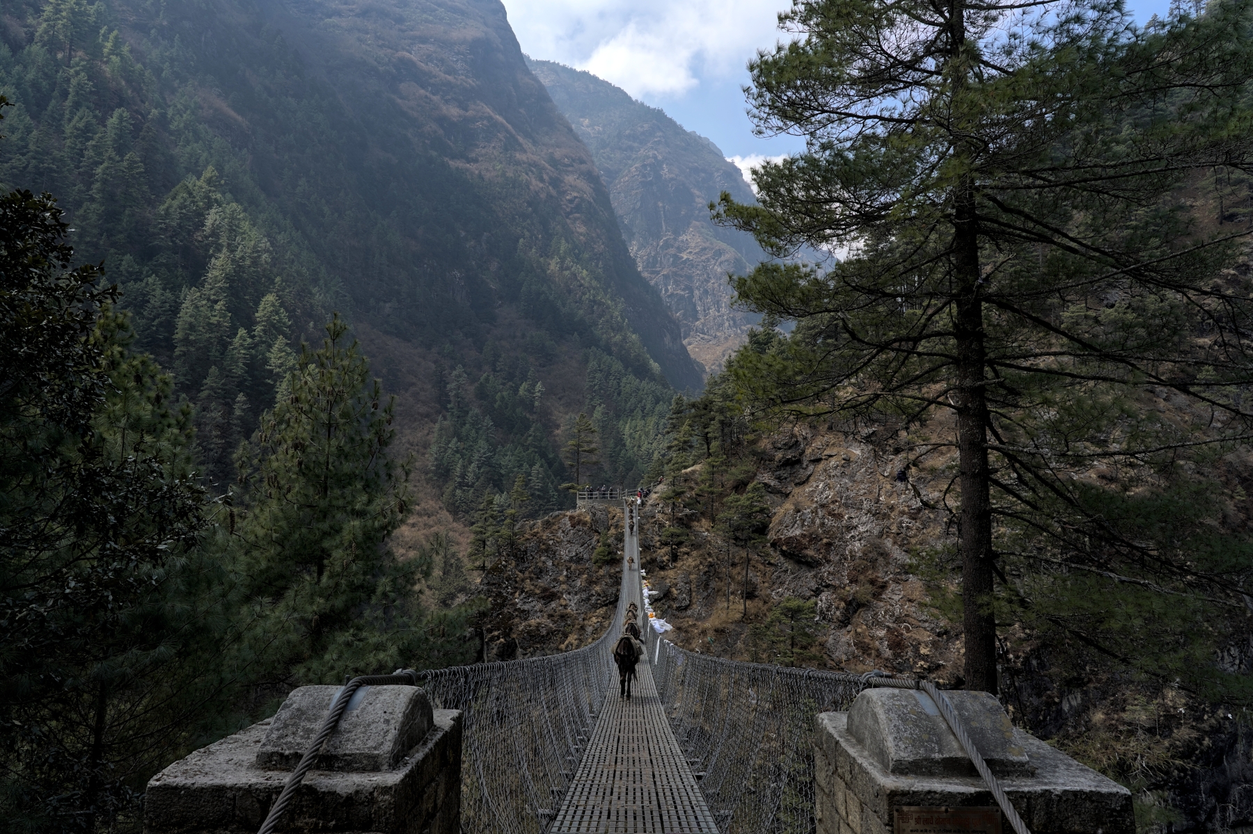
The infamous Hillary Bridge, looking westward towards Namche Bazar
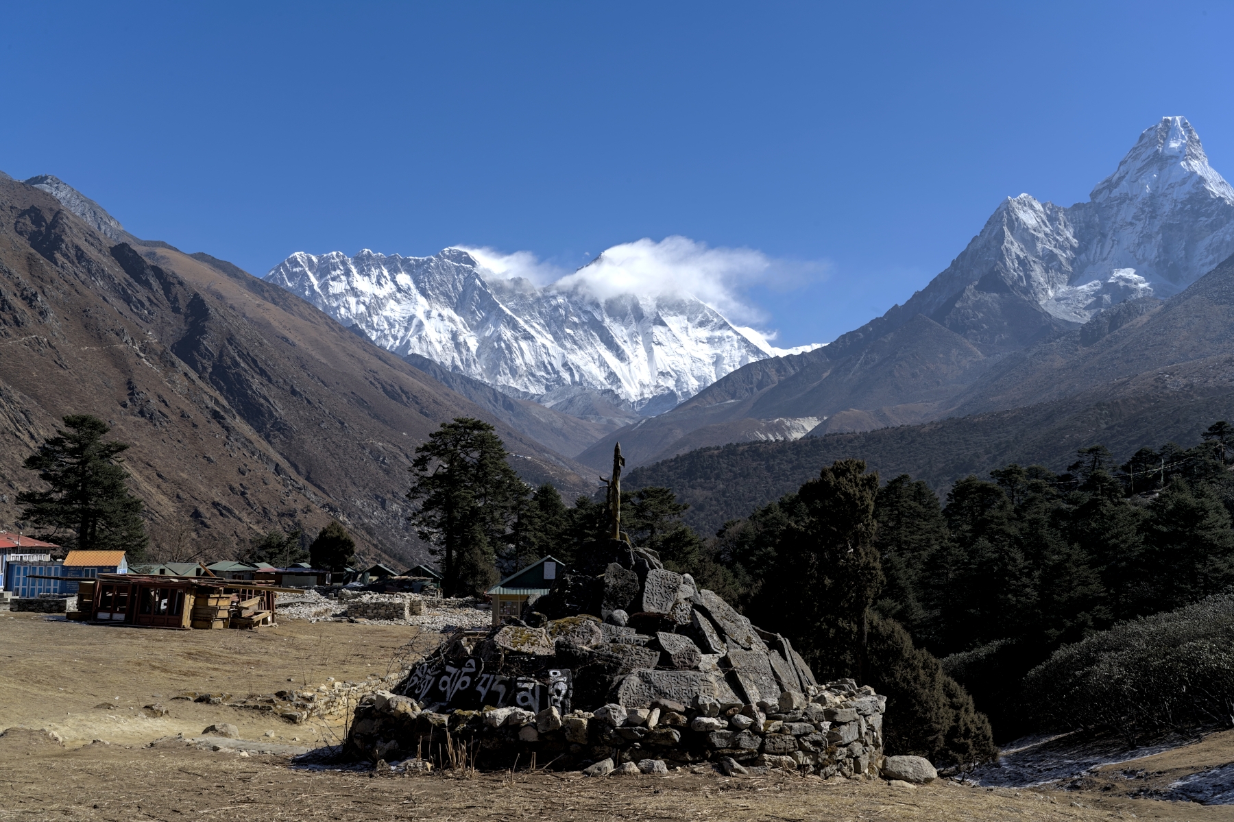
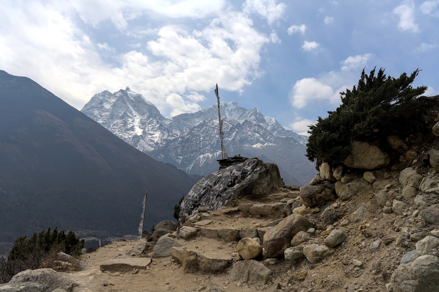
After a couple hours of walking uphill the trail rounds a bend and the hillside town of Namche Bazar appears above, like an amphitheater of teahouses and shops. Namche Bazar is over 2,000 meters higher in elevation than Kathmandu and around 800 meters higher than the location of last night’s sleep, so a rest day to help acclimatize is a must. Thankfully, unlike a lot of other acclimatization spots in Nepal which can be a bit boring, there is a lot to do in Namche Bazar. It is full of cafes with all kinds of delicious baked goods, quality restaurants serving a wide range of cuisines from around the world, and even some bars to relax and unwind. While alcohol should be avoided until you’re on your way back down the mountain, the bars in Namche Bazar also sell non-alcoholic items and tend have free Wi-Fi, while also playing documentaries/movies in the afternoon. Some bars have pool tables, darts, and other games, and there is even a bar with live music!
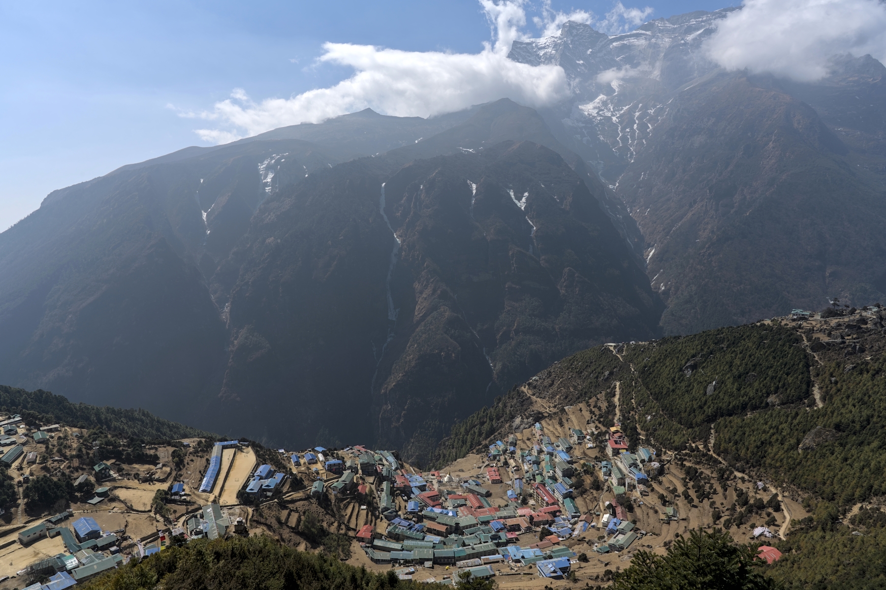
Namche Bazar from above. You will see this viewpoint three times on your trek
After gaining 800 meters in elevation on the previous day, your body will need time to adjust. But your “rest” day in Namche Bazar shouldn’t be a lazy one, because an acclimatization hike is one of the best ways to cope with the altitude gain. The maxim of “hike high, sleep low” is well-known in the mountaineering community and it certainly applies to Namche Bazar. Hiking to a higher altitude during the day and then returning to Namche Bazar to sleep helps far more with acclimatization than simply relaxing in bed would. The two most popular acclimatization hikes are: 1) to the Everest View Hotel or 2) to Khumjung Village, both of which are worthwhile trips.
Most trekkers choose to hike to the Everest View Hotel, which is a luxury hotel located at nearly 3,900 meters altitude. The trail here is a fairly steep uphill climb along stone steps and eventually a rocky, dirt path until it reaches a plateau above Namche Bazar. Once the trail reaches this plateau, the rest of the hike becomes a relatively flat and rather enjoyable walk. At the end of this walk is the Everest View Hotel, a luxury hotel that boasts the title of being the highest hotel in the world. The hike to Everest View Hotel is the most popular acclimatization hike in Namche Bazar because at the end of the hike, trekkers spend a half hour or so enjoying a cup of tea and a snack while admiring the incredible views of Mount Everest, Lhotse, Nuptse, and Ama Dablam. Trekkers return to Namche Bazar by the same route, with the trek typically taking 3-4 hours roundtrip to complete.
View from Everest View Hotel. Lhotse is covered in clouds, while top of Everest (with clouds behind it) is in center
But for those looking for something a bit more challenging and/or off the beaten path for their acclimatization hike, Khumjung Village is a perfect alternative. Khumjung is one of the largest Sherpa communities on earth where thousands of Sherpas live year-round; farming the land, raising yaks, and of course acting as mountain guides. Unlike the nearby Namche Bazar, this village is not a major stop on trekking routes, and as a result, it shows Sherpa life as it has existed for centuries. Khumjung is a beautiful place to stroll the narrow paths, admire the beautiful scenery, and purchase local wares that benefit the community. And of course, a trip to Khumjung wouldn’t be complete without a visit to the Khumjung Monastery, the center of the local community, and according to legends, home to a real yeti skull!
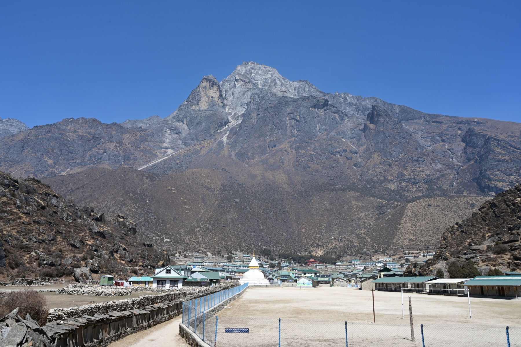
Khumjung village, with Khumbila (5,761 m), a holy mountain for the Sherpa people, in the background
The trek to Khumjung is a little bit longer and a bit more difficult, but if you’re really into hiking and want to see real Sherpa life, I think it’s totally worth it. But regardless of which acclimatization hike you choose, you be back in Namche Bazar around lunch time, after which the rest of the day is yours to enjoy. Do some shopping, have a cup coffee and a local pastry, or my favorite: enjoy a documentary about the Himalayas in one of the local bars such as Yeti Bar or Liquid Bar. The documentaries usually relate to Mount Everest and mountain climbing, with common showings including: Into Thin Air, Sherpa, and The Conquest of Everest.
Watching one of these documentaries at 3,400 meters elevation on your way to EBC really hammers home their message and will leave you feeling awed. And although drinking alcohol is a big no-no on your way up the mountain, these bars are also quite happy to serve you tea and snacks instead. Whatever you choose to do in the afternoon, be sure to eat a good dinner and get to bed early so you’re rested and full of energy for the next day’s hike.
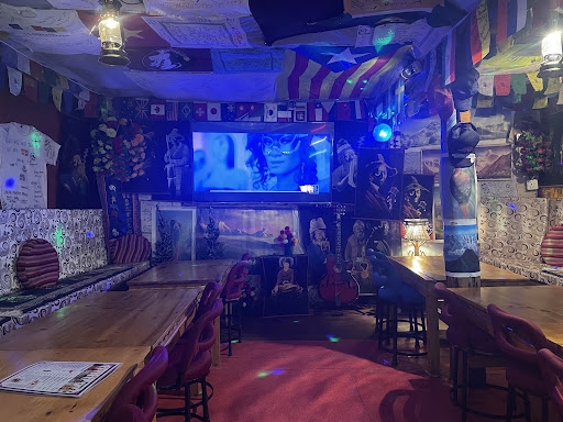
Typical view from inside a local Namche Bazar Bar
The following morning the trek continues towards Tengboche. After climbing the hill to join the trail above Namche Bazar, the first two hours or so of the trek will be quite enjoyable. Once again, this section can be described as “Nepal flat,” with some ups and some downs, but for the most part even terrain. The trail in this section is mostly packed dirt with some stone stairs, hugging the side of hills and mountains overlooking the Dudh Koshi River. While hiking this section, incredible views Mount Everest, as well as Lhotse, Nuptse, and Ama Dablam are ever-present in front of you. The only thing that will slow you down on this easy section of trail is stopping to take photos as you round every bend.
Unfortunately, while the first half of the trek is relatively flat and easy going, the second half is anything but. After 2-3 hours of hiking the trail heads downhill towards the Dudh Koshi River, around 500 meters below. The trail in this section is steep at times and consists of many dirt switchbacks through dense forests. The dirt in this section is rather loose in contrast to the hardpack you encountered earlier, and it can be quite slippery in wet weather or when covered in tree needles and other debris. That said, this section can also be quite enjoyable (unless you have bad knees). Eventually the trail reaches the river, which is the perfect spot to stop for lunch.
After eating, there is a good chance it will dawn on you: “Tengboche is around 400 meters higher in elevation that Namche Bazar.” You will then likely remember the hike so far, and will think to yourself, “I feel like after that downhill section before lunch, I’m at a lower altitude than I was when I started my hike.” And you would be correct. The altitude as you cross the river toward Tengboche is more than 100 meters lower than Namche Bazaar, which means you’ve got around a 500-meter climb ahead of you. This section of will feel a lot like the hike from the Hillary Bridge to Namche Bazar from two days earlier; walking steadily uphill along dirt and rock switchbacks, with a canyon and river to one side and a hill, on top of which is your destination, on the other. But after a few hours you reach the top of the hill, with the Tengboche Monastery to your left and Mount Everest in front of you off in the distance.
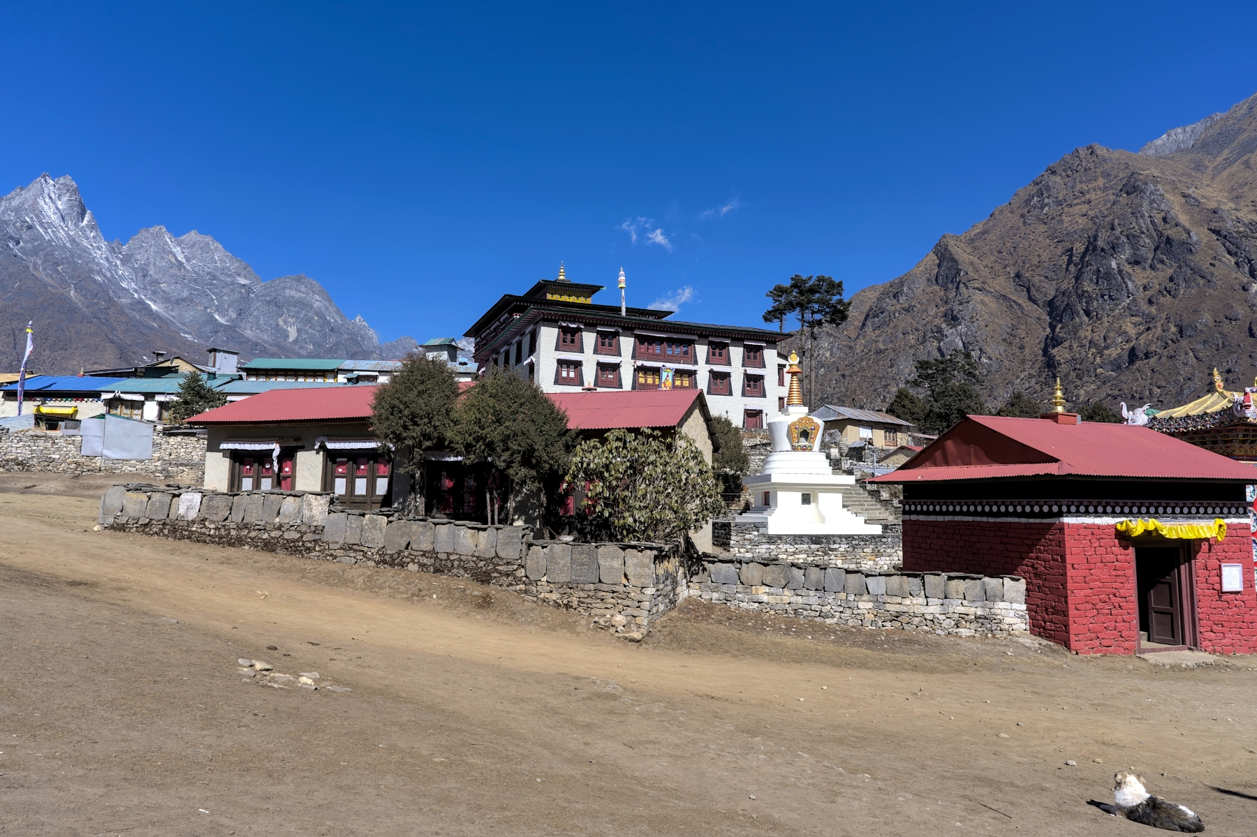
Tengboche Monastery in mid-morning
By the time you reach Tengboche, the clouds will have likely moved in and there won’t be much to see. But don’t worry, the weather in the morning is usually nice here, plus you will pass by here again on your way back down from EBC . In other words, you’ll have better chances of seeing the amazing view from Tengboche later in your trek. Assuming you aren’t too tired after the day’s hike, I’d recommend dropping your belongings at your teahouse and heading over to the Tengboche Monastery. Photographs aren’t allowed inside the inner parts of monastery, but sitting down in a corner, watching and listening to a roomful of monks praying and banging drums in their winter robes is a cool experience.
View from Tengboche. Ama Dablam (right) and Everest (middle left), with Lhotse behind clouds
The following morning the trek begins with one of the best “views from the starting point of the hike” in the world. After appreciating the early morning beauty of the Everest Massif and Ama Dablam, the trail heads downhill and meanders through dense forests, with plenty of trees but very few views to speak of. However, this section is relatively short, and in less than an hour the trail will reach a suspension bridge that crosses the Imja Khola River.
Imja Khola bridge looking East. Deboche (lower right) and Tengboche (far right) visible from here
Once on the other side of the river, the trail will feel remarkably similar to the morning portion of the hike from Namche Bazar to Tengboche. Once again, the trail hugs the side of hills and mountains, with the Everest Massif and Ama Dablam in front of you, and a river (this time the Imja Khola and not the Dudh Koshi) below you to your right. The trail is a bit less flat than the morning portion of yesterday’s hike, but it’s still an easy, gradually uphill hike along a mostly hardpack dirt and stone trail. There are few small settlements along this trail, so stop for lunch whenever you get hungry. I’d recommend Shomare, as it splits the day up nicely and leaves you some time to digest before reaching the river, where the trail begins to get more difficult.
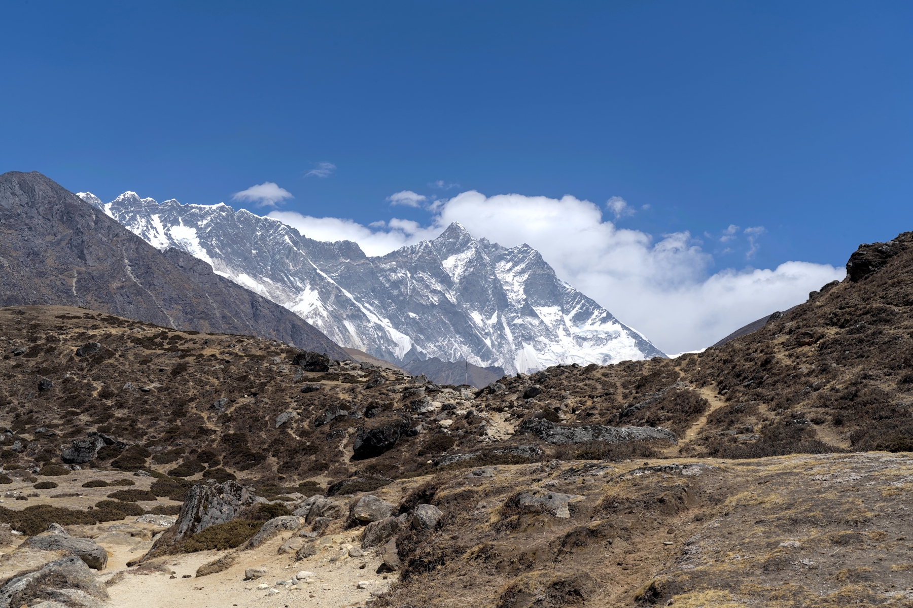
View of Lhotse (8,516 m) from the trail between Tengboche and Dingboche
Eventually the trail will begin to head back downhill towards the river. You might be thinking: “Not again! Why am I going down when Dingboche, the next stop on the trek, is around 300 meters higher than here?” I’ve been frustrated more than once during this section of the trail, but don’t worry, it isn’t as bad as it the day before! This time the trail only loses around 150 meters of altitude before reaching the river, and the climb from the river to Dingboche is easier than the climb the day before. Once the trail crosses the river, it takes on a now-familiar form: a hardpack dirt/stone path hugging the side of a hill, with a river below and to the right and mountains on the other side of it. Fortunately, this is the last time on this trek that the trail can be described this way (unless you consider 6,000+ meter mountains to be “hills” and the Khumbu Glacier to be a “river”). This is also the last point in the trek where you will see trees, as the remainder of the trail to EBC lies above the tree line!
After an hour or so the trail will level out and lead to a bowl-shaped valley with rolling hills weaving their way through it. In the late afternoon, this valley tends to be quite cloudy, as it is a confluence of three valleys; one heading east towards Island Peak, Baruntse, and Makalu, another heading north towards Everest, Lhotse, and Nuptse, and the third heading back towards Tengboche and Namche Bazar. If you’re lucky, the weather will remain clear and you’ll see some incredible views, otherwise you’ll have better opportunities over the next two days to see this area in good weather.
Lhotse in early afternoon on a day with good weather. Tingboche is just beyond the hill
After gaining approximately 600 meters in altitude since leaving Tengboche (and nearly 1000 meters since leaving Namche Bazar), an acclimatization day in Dingboche is a good idea. Although the choices for acclimatization hikes in Dingboche aren’t as good as in Namche Bazar, once again there are two main options. The first option, taken by around 99% of trekkers, is a hike up Narkang Hill. Also sometimes referred to as Nakarsang and Nangkartshang, this hill looms over the north side of the valley where Dingboche is located. Few trekkers climb to the actual peak of this hill, which is approximately 600 meters above Dingboche; instead, most hike anywhere between 200 and 400 meters higher. Remember, the purpose of this hike is acclimatization, so while you don’t want to stop too early and not get the benefits of higher altitude, you also don’t want to push yourself too hard and develop or exacerbate symptoms of altitude sickness. Listen to your body, and stop when you feel like you are starting to get tired.
The trail consists of sections of hardpack dirt, loose gravel, and rocky terrain, and although the trail is easy to navigate, it gains elevation quickly. You will feel like you’ve walked up many flights of steep stairs, and flat portions to catch your breath are few and far between. Take your time and stop if you need to; this is a short day of hiking so there is no need to rush. Unlike most of the trekking so far, the trail in this section isn’t linear, meaning there are a variety of paths to follow up the hill. This is largely because the “trails” on this hill are actually yak trails, carved into the mountain over many years as these heavy animals climb the hill in search of plants for grazing. While some enjoy having options as to which trail to take, others might get a bit nervous about which trail to take. When in doubt, follow your guide, or if you are trekking without a guide, just follow the crowds. It’s almost impossible to get lost here!
View from midway up Narkang Hill. The bottom reaches of Ama Dablam can be seen on the far left
Aside from being important to your acclimatization, this hike is great because it offers some incredible views! The views over the last few days, though objectively fabulous, were likely starting to get a bit repetitive. The Everest Massif in front of you, a chain of smaller hills and mountains to your left, a river below you to your right, with Ama Dablam beyond it… as lovely as that view can be, by this time in the hike you’re probably wanting a change of scenery. You’ll get it here, with views of Ama Dablam from the opposite side as you’ve been experiencing thus far, as well as all the mountains that were behind you as you hiked to Tingboche. The foreboding South Wall of Lhotse can also be seen from this hill, and as you scan to the right you will see other beautiful mountains, including Makalu, the 5th tallest mountain on Earth at 8,485 meters, and Island Peak, a popular trekking peak. 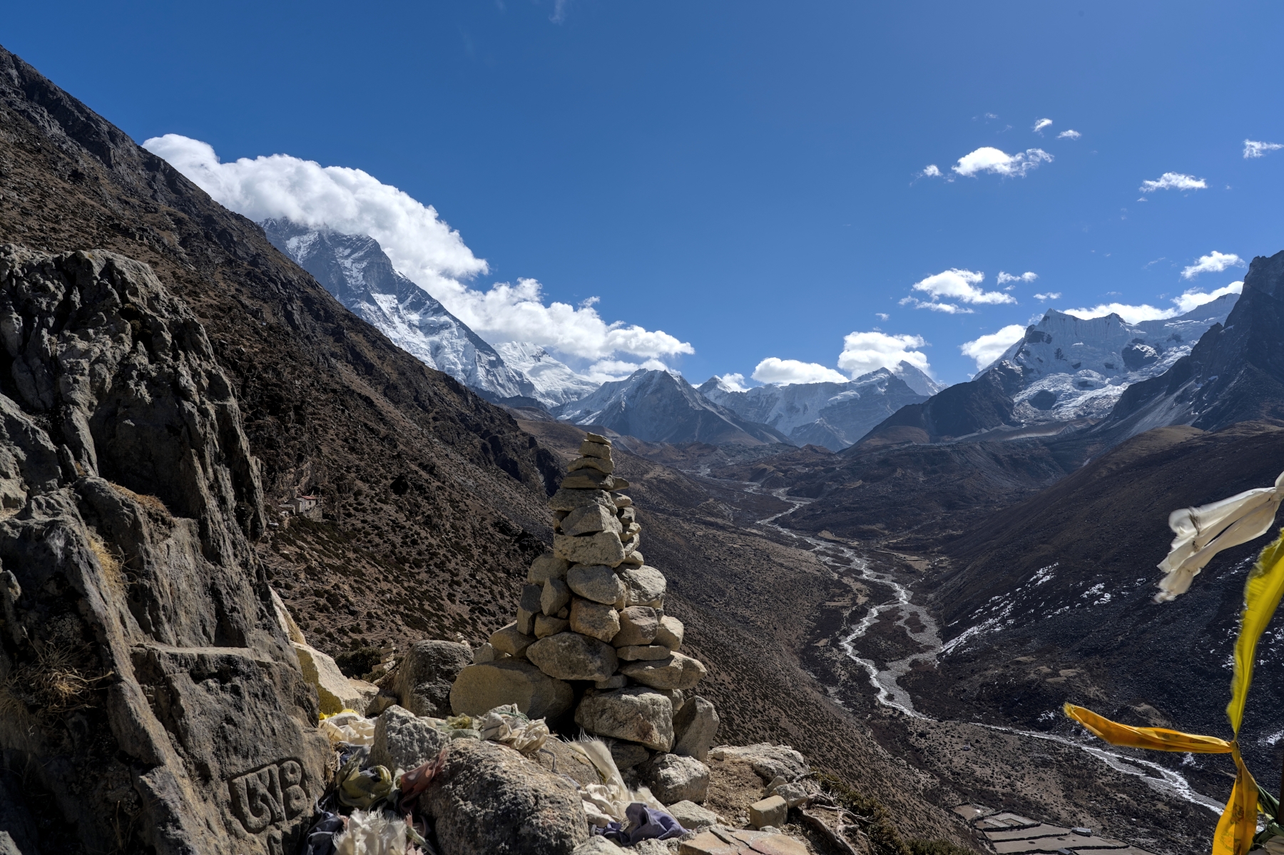
View from Narkang Hil looking east. Island Peak (center) and Makalu (8,485 m) to its right. Lhotse (left) behind clouds
The other, far less popular option for an acclimatization hike is a walk towards Chukhung. Chukhung is a small settlement at approximately 4,700 meters elevation, and is a stop on the legendary Three Passes Trek as well as the last stop before Island Peak Base Camp. Chukhung is a very unremarkable location that exists solely to cater to trekkers and mountain climbers, so hiking the 3-4 hours that it would take to get here is not worth it. But after hiking for around 2-2.5 hours, you will reach the Jerzy Kukuczka Memorial, a small stone monument dedicated to the second man to climb all fourteen 8,000-meter peaks. Behind this memorial is the South Wall of Lhotse, where Kukuczka tragically lost his life in 1989. After learning about Kukuczka’s life, seeing this monument, with Lhotse in the background, is a beautiful yet somber reminder of the power of these mountains. And though the hike here is a bit longer, the trail is more even and the elevation gain is far more gradual than the hike up Narkang Hill. 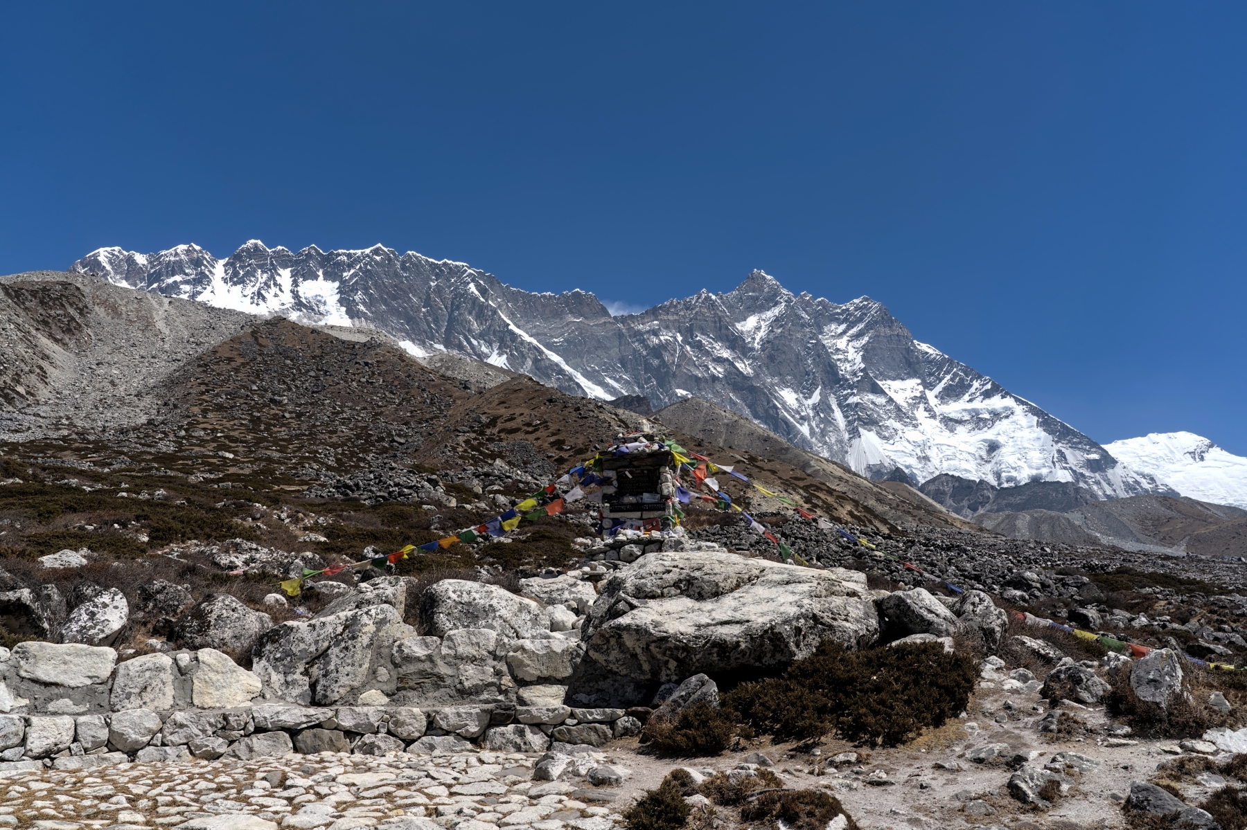
The Jerzy Kukuczka Memorial, with the South Wall of Lhotse looming in the background
Either way, after your hike you will return to Dingboche and spend the whole afternoon relaxing and preparing for the hike to Lobuche the following. Make sure to get a good night’s sleep, because come tomorrow, you are in for a treat. That’s because the trek from Dingboche to Lobuche is, in my humble opinion, the best day of the trek. Full stop.
The hike begins by climbing a small hill that leads into a long valley, with the massive, 6,000+ peaks of Tobuche, Tabuche, and Cholatse on the left, Pokalde Peak and Narkang Hill on the right, and a small stream running down the middle. The trail in this section isn’t clearly defined, as it consists of narrowing yak trails weaving their way through the dirt, moss, grass, and sage brush covered ground. At first, just like the Narkang Hill climb from the day before, the trail is non-linear, and you might see other trekkers higher up the hill to your right or closer to the stream on your left. Don’t worry, there is more than one path in this section and as long as you keep heading up the hill to the right of the stream, you can be sure that you’re heading in the right direction. 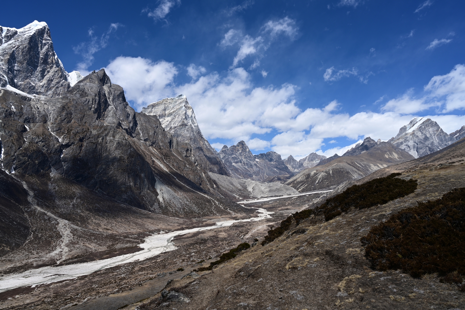
View of the valley heading towards Lobuche (right) and Gokyo (left)
Eventually these yak trails will combine and will lead to a single, hardpack dirt trail which continues through the valley, steadily gaining elevation. The trail passes cozy-looking, stone huts used by yak herders as they allow their herds to feed in this area during certain seasons. These stone huts, with their stone walls and pens, when juxtaposed against the harsh mountain background make for some evocative (and beautiful) photo opportunities. 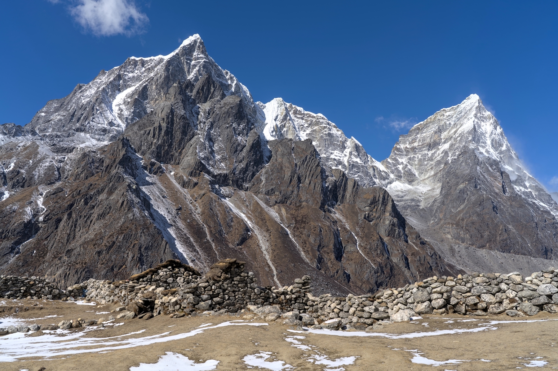
Tabuche (left – 6,495 m) and Cholatse (right – 6,501 m), with small yak herder hut in foreground
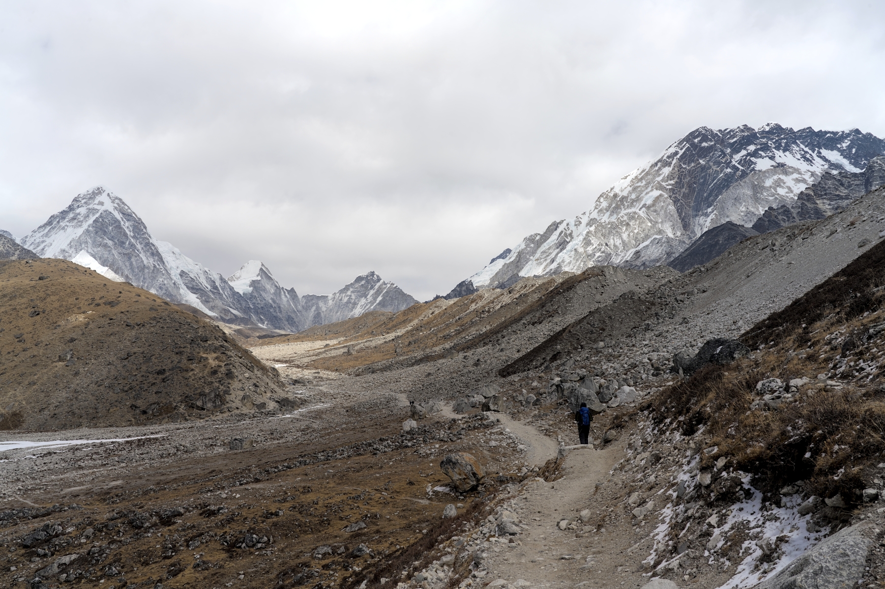
As the hike continues uphill, the trail and the terrain will get a bit rockier, and the scenery a bit more rugged as the grass and brush become more rare and less dense. Eventually the trail reaches Dughla (also known as Thukla), a small settlement that exists solely for trekkers, as it sits at the confluence of the EBC Trail and the trail between the Kongma La and Cho La passes on the Three Passes Trek. Thukla is extremely small, consisting of a few basic teahouses, but what it lacks in size it makes up for in scenery. This is essentially the only place where food can be had between Dingboche and Lobuche, so everyone stops here for lunch and to refill their water.
After lunch the trail leads uphill to the Thukla Pass (or Dughla Pass, take your pick). This is a steep, uphill climb along dirt and gravel switchbacks for what seems like an extremely long time. As much as this section can be a bit tiring, due to the steep nature and the relatively thin air, the trail itself is in good condition. If you start to get tired, just stop for a second and gaze back down the mountain, where you will see a stunning, unbroken chain of mountains along the horizon. That will get your spirits up for more climbing. 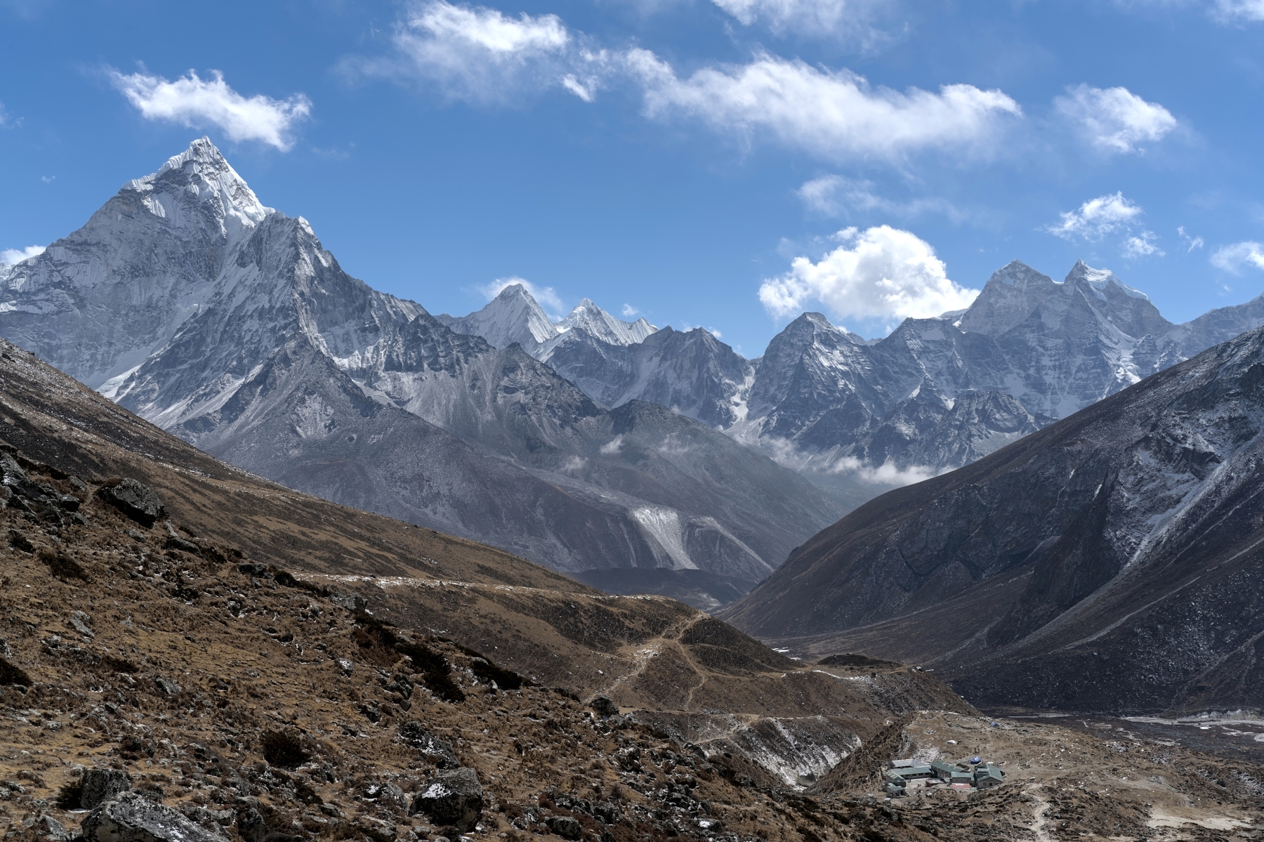
View looking south from nearly halfway up the Thukla pass. Thukla is the small village at bottom right
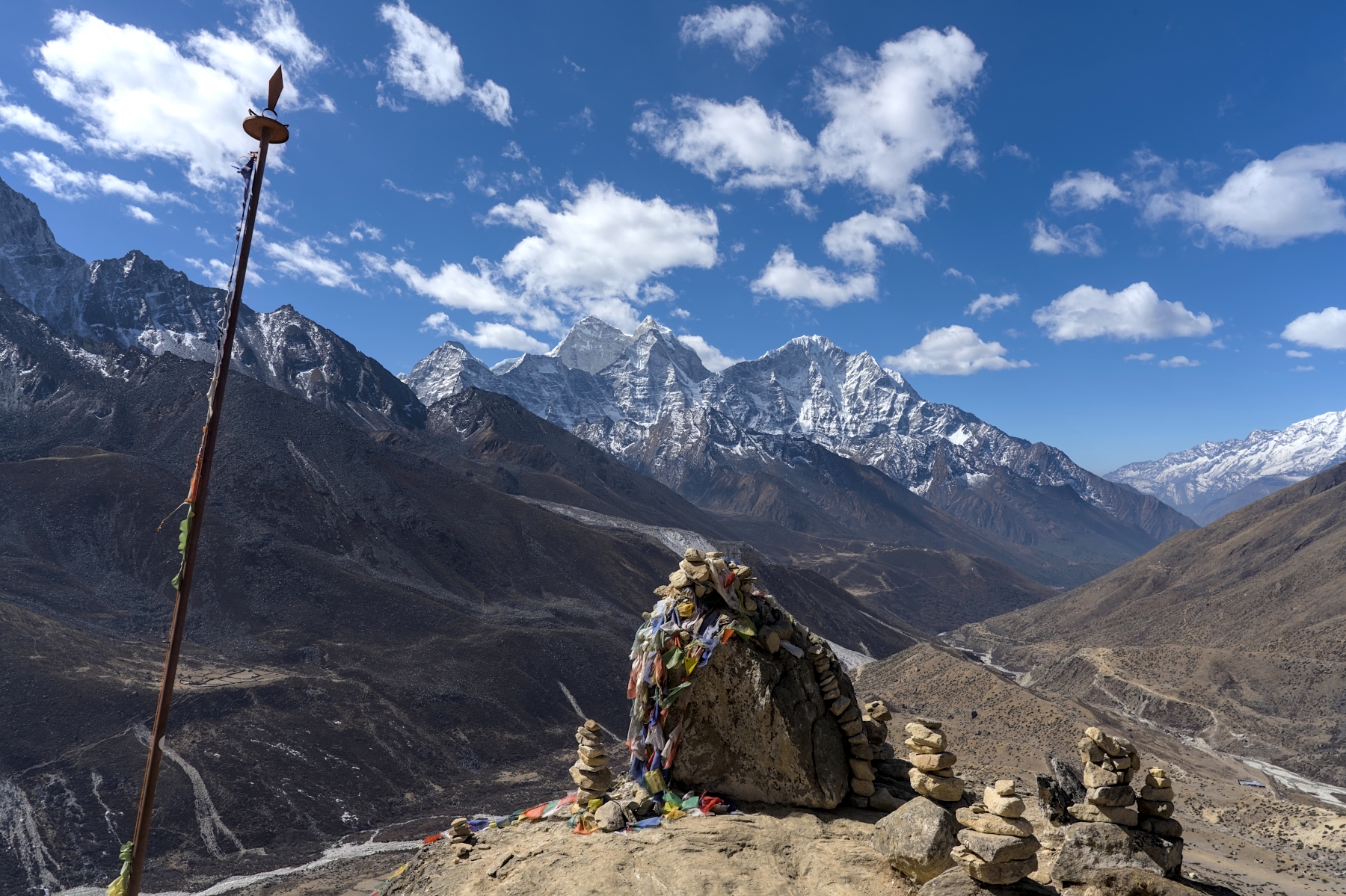
After around an hour of climbing, the trail reaches a plateau. But this isn’t your average plateau, this plateau is a valley that is also home to countless memorial stupas for climbers and Sherpas who lost their lives on Everest. The sight of hundreds of these stone monuments is a chilling reminder of the power of these mountains and the dangers they pose to anyone attempting to conquer them. Each of these memorials has a heartbreaking story behind it, from memorials to well-known victims like Scott Fischer, Rob Hall, and the others who perished in the 1996 Everest disaster, to memorials for those known only to their families and the mountaineering community. Each of the stupas here has a story to tell, and although here is no cellular or internet service here; by taking some photos of the memorials on your phone you can read about them once you’re back in Kathmandu. 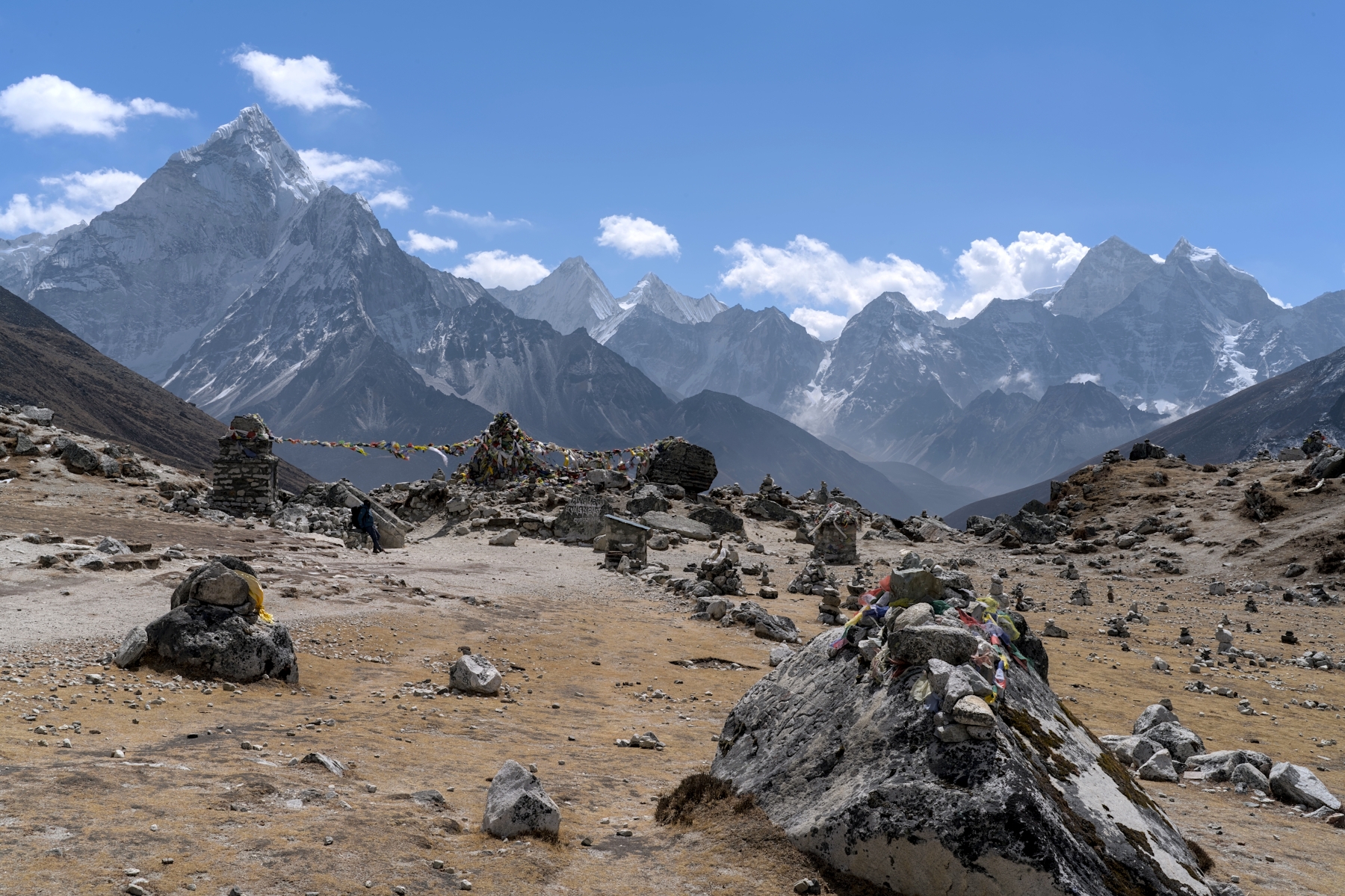
View of memorial stupas and mountains from the Thukla Pass. Ama Dablam is the mountain at far left
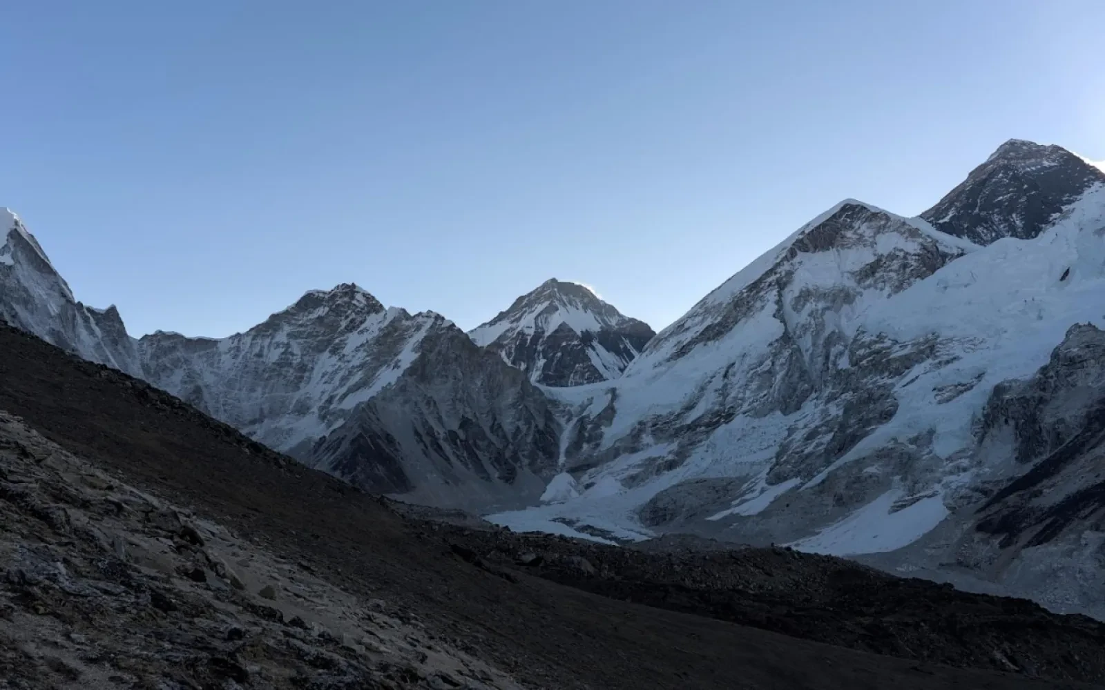
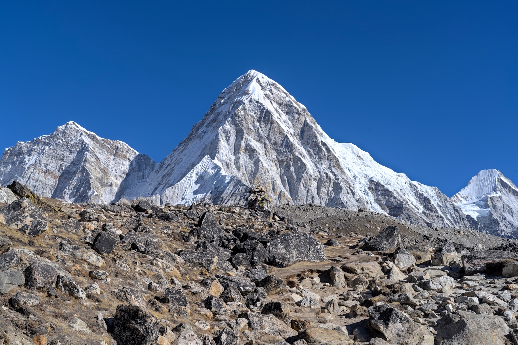
Although all the memorial stupas might give this plateau a somber vibe, you would be forgiven for not feeling it because of the incredibly beauty of this place. Look down the mountain in the direction of Dingboche and there is an incredible wall of mountains, with the incomparable beauty of Ama Dablam looming on the left end of the wall. To the right of the wall are the beautiful peaks of Tobuche, Tabuche, and Cholatse, towering over the valley below. Turn around, and you will see for the first time Pumori, a stunning, 7,161-meter mountain shaped like a pyramid, with the even more interestingly shaped Lingtren beside it to the right and Khumbutse beside that. These three mountains form the western part of the Everest Massif and are connected to Mount Everest, along with its neighbors Changtse, Nuptse, and Lhotse, via the western ridge and the Rongbuk Glacier. Unfortunately, Nuptse, Lhotse, and Mount Everest aren’t yet visible yet, but after seeing some of the other neighboring mountains for the first time, you know they’ll be visible soon enough it. Every direction you turn on this plateau, you will see some of the most beautiful scenery imaginable. It is, in my humble opinion, the most beautiful place in Nepal. 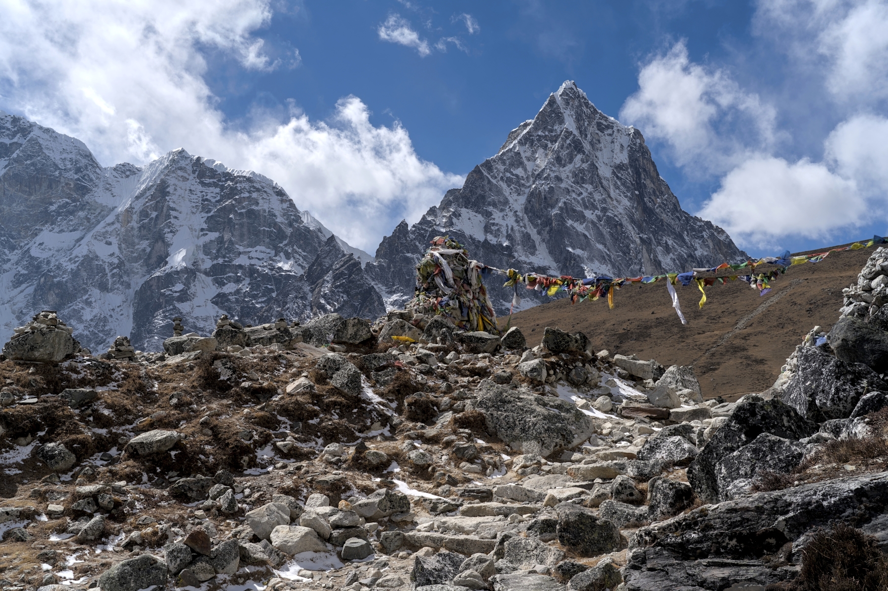
Memorial Stupa with prayer flags. Cholatse and Tabuche in background
After spending time taking photos and admiring the views, the trek continues up the hill towards Lobuche. As the trail leaves the plateau it becomes hardpack dirt with a thin layer of loose gravel, with a few rocky sections here and there. In this section the trail is well defined and quite flat, as it weaves through a valley that was carved by a now-receded glacier. There are a few sections where the loose gravel can be a bit slippery, but overall it’s a quick, easy, and enjoyable stroll to end the day. In front of you as you walk you will see the ever-present views of Pumori, Lingtren, and Khumbutse, as well as the now visible Changtse, Nuptse and the West Shoulder of Mount Everest to the right of the three aforementioned mountains. The trek ends in Lobuche, tiny settlement at 4,900 meters altitude consisting of a few basic teahouses that exist only to serve trekkers heading to EBC. Get a good night’s sleep tonight, because tomorrow afternoon you will finally reach EBC!
View from trail between Thukla and Lobuche. From left, Pumori, Lingtren (6,749 m), Khumbutse (6,665 m), and Nuptse
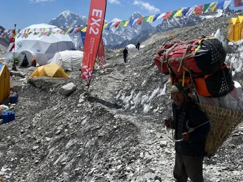
Today is the big day! After a quick pit stop in Gorak Shep the trek will finally reach EBC in the early afternoon. But before getting to EBC, there is a great day of hiking to be had. Not long after leaving Lobuche, to the right of the trail appears a mass of gray gravel and rock with white and blue snow and ice underneath. This is the famous Khumbu Glacier, which extends all the way to Everest Base Camp before turning sharply to the right between Everest and Nuptse, forming the infamous Khumbu Icefall. But worry not, the trail stays to the left of the Khumbu Glacier the whole time, so crampons and safety lines won’t be necessary!
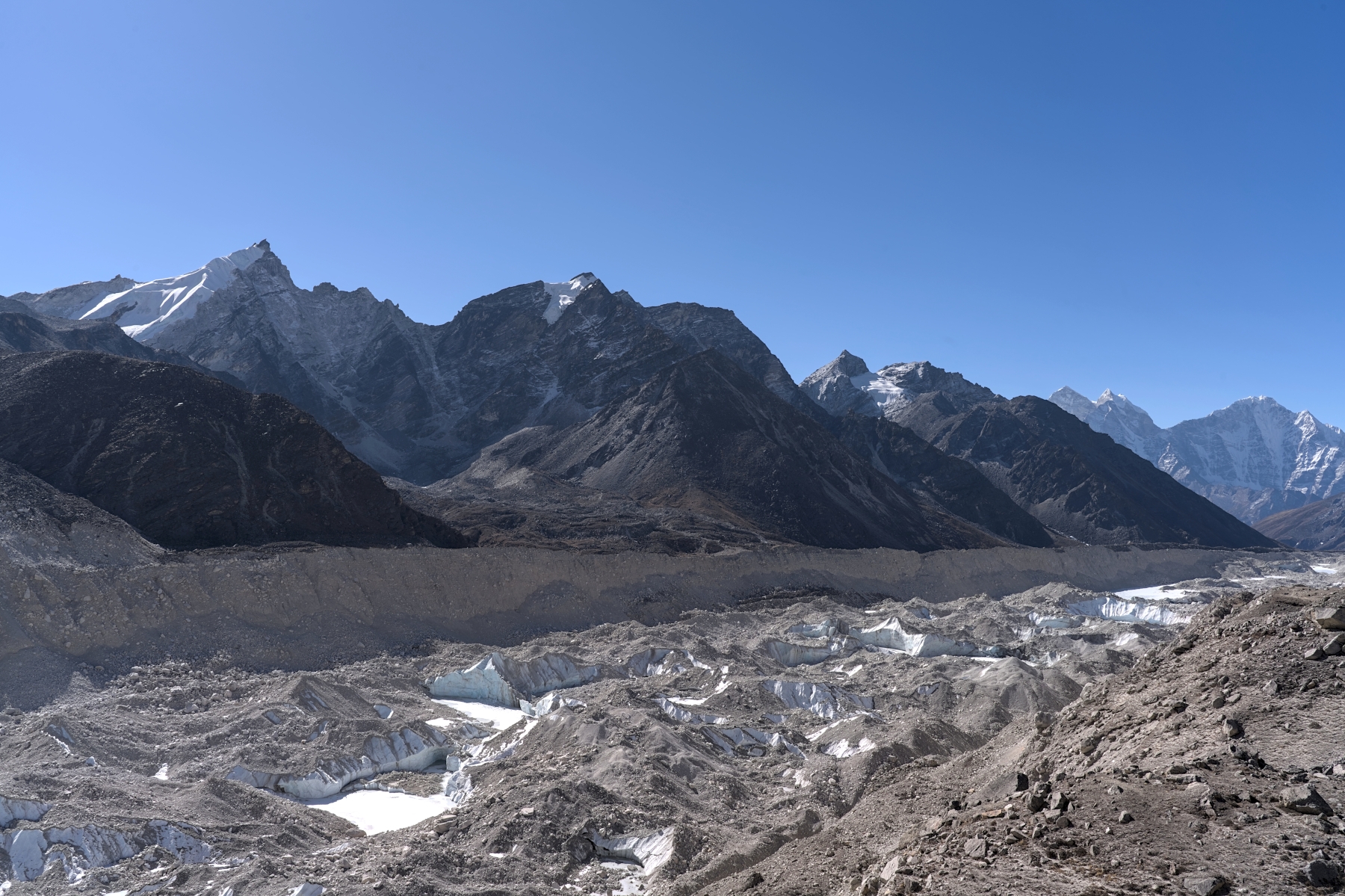
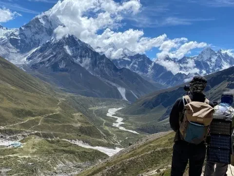
View of the Khumbu Glacier (facing South) from the trail between Lobuche and Gorak Shep
The trail from Lobuche to Gorak Shep varies, though in general the rise in altitude is quite gradual. At times the trail will be narrow, hardpack dirt paths crisscrossing valleys covered in small tufts of yellow moss and grass. At other times the trail will consist a loose gravel path snaking its way along rolling hills. And at other times the trail will be quite rocky, ranging from coarse gravel to small boulders. All the while the amphitheater of mountains surrounding EBC appears in front, and the Khumbu Glacier and the wall of mountains beyond it to the right. In terms of the actual hiking trail, the section from Lobuche to Gorak Shep is arguably the best on the entire trek, given the relatively gentle rise in elevation, the variety of hiking terrain, and of course the incredible views on all sides. After a couple hours of the trail reaches Gorak Shep, the final stop on the trail before Everest Base Camp. Everyone (including the guide and porters) will drop off their bags and belongings, taking only a small day pack with them for the final push to EBC.
View of trail to EBC from Gorak Shep. From left, Khumbutse, Changtse (7,543 m) and the West Shoulder of Everest
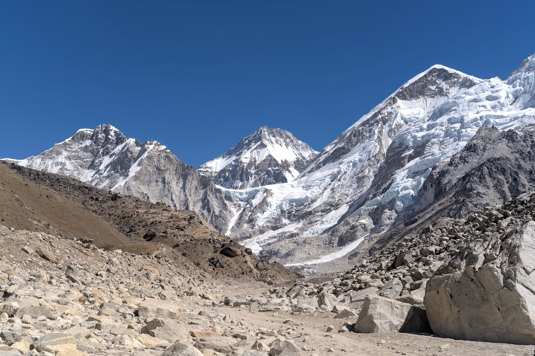
The first half of the trail ranges from gravel-covered, hardpack dirt to loose scree and even some sections that border on bouldering. Although the trail climbs steadily (EBC is over 200 meters higher than Gorak Shep), due to the rocky terrain the trail undulates considerably. The trail goes up, then down, then back up again, all while twisting and weaving its way between rocks and boulders. After a half hour or so the trail will straighten out considerably, as you walk along a rocky ridge that tracks path of the Khumbu Glacier. This section becomes a bit rockier while continuing to undulate, but it has the added bonus of an unbroken line of sight to the amphitheater that surrounds EBC, and at times the tip of Mount Everest itself. Your guide will likely point out the spots where you can see Everest along this section of trail, but watching those trekking in front of you and seeing where they stop can also give you hints. 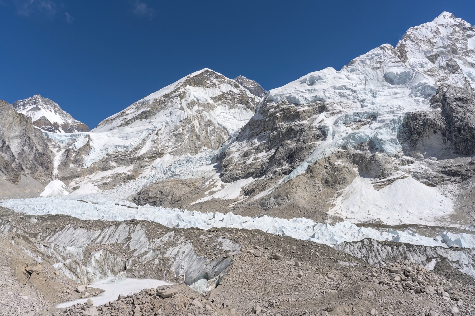
View from trail to EBC. From left to right, Changtse, Everest West Shoulder (7,309 m), Everest, and Nuptse (7,861 m),
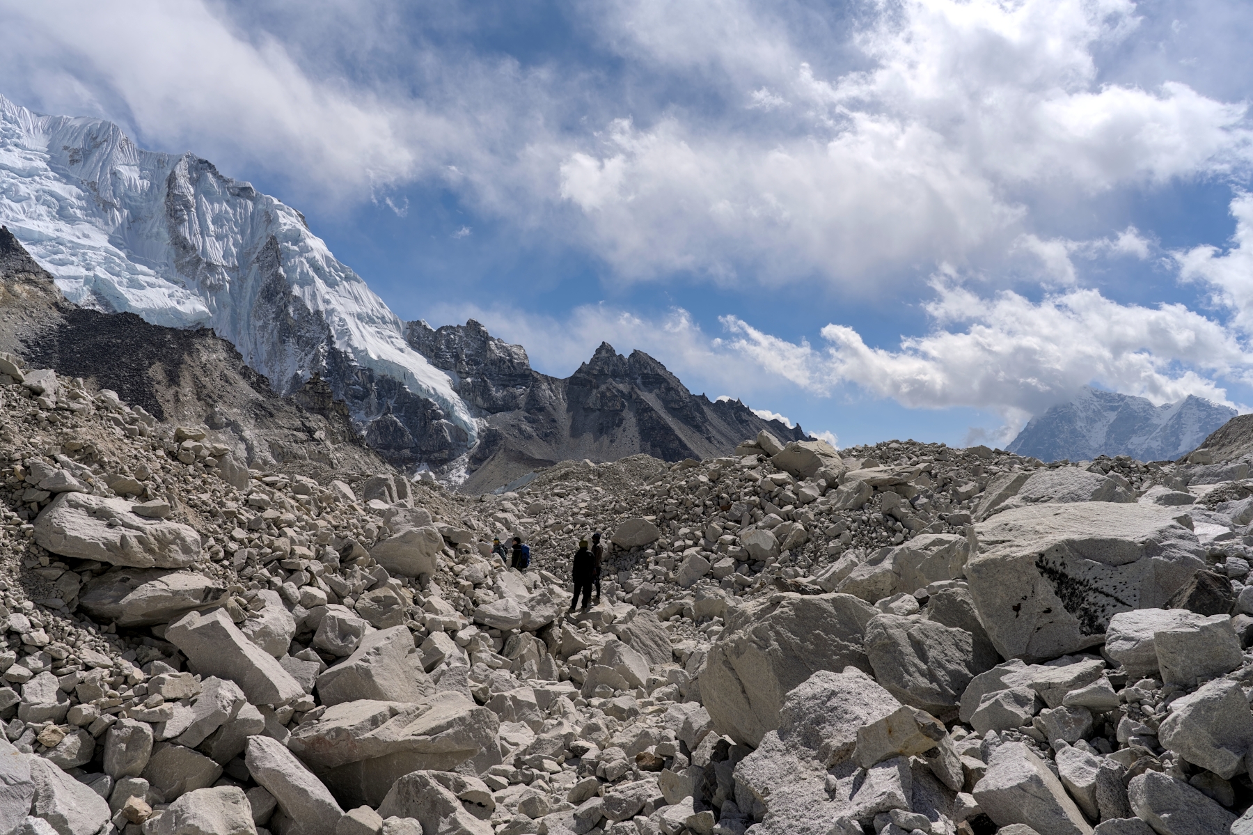
Eventually the trail leaves the ridge that it has been following for some time and begins to head down the ridge in the direction of the Khumbu Icefall. The trail gets really rocky at this point, with loose scree covering the trail and large boulders on all sides. At some points there will be a bit of bouldering to do; nothing too crazy, but be careful where you step because the footing here is not very sound. As you wind through the boulder field, walking uphill or downhill depending on the arrangement of the rocks, you will eventually encounter icy crevasses that, although off the trail, present a real danger to anyone who walks towards the edge to try and take a look inside. 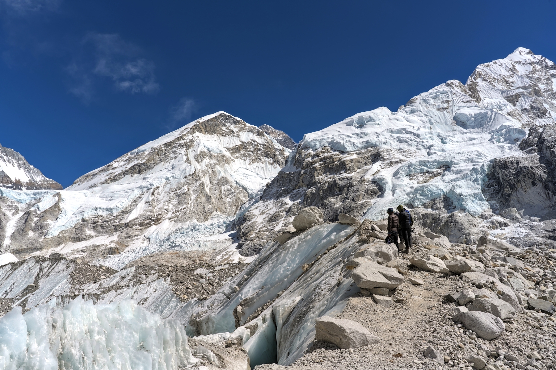
The trail from 30 from base camp. Icy crevasses below, and Everest, its West Shoulder, and Nuptse above
Depending on the time of year, your arrival at EBC might be easy to see coming. The closer it gets to May and November (the two main months for summiting), the more that Base Camp will be filled with tents, prayer flags, and people. You’ll see the bright colored tents of EBC from the trail hours before you actually reach it. But if you go between December and late-February or June and late-August, the sometimes-ubiquitous tents at EBC are gone, and EBC can sneak up on you. As you head downhill through a boulder-lined gully, in the direction of Gorak Shep, it suddenly opens up and looking to your left you can see the infamous EBC rock. But regardless of the time of year, as soon as you see that rock it finally hits you: “I’ve made it to Everest Base Camp!”
Now is a time to celebrate. Take pictures of everything and everyone. Sit under the precariously perched rock or climb on top of it to have your photo taken. Walk towards the edge of the Khumbu Icefall and gaze into its vastness. With your eyes, try and follow the path through which climbers weave their way uphill through the icefall towards the South Col. Stare in awe at the massive Pumori, Lingtren, Khumbutse, Changtse, Nuptse, and Everest looming above you. Soak it in, you’ve accomplished something few others have, and will forever have bragging rights.
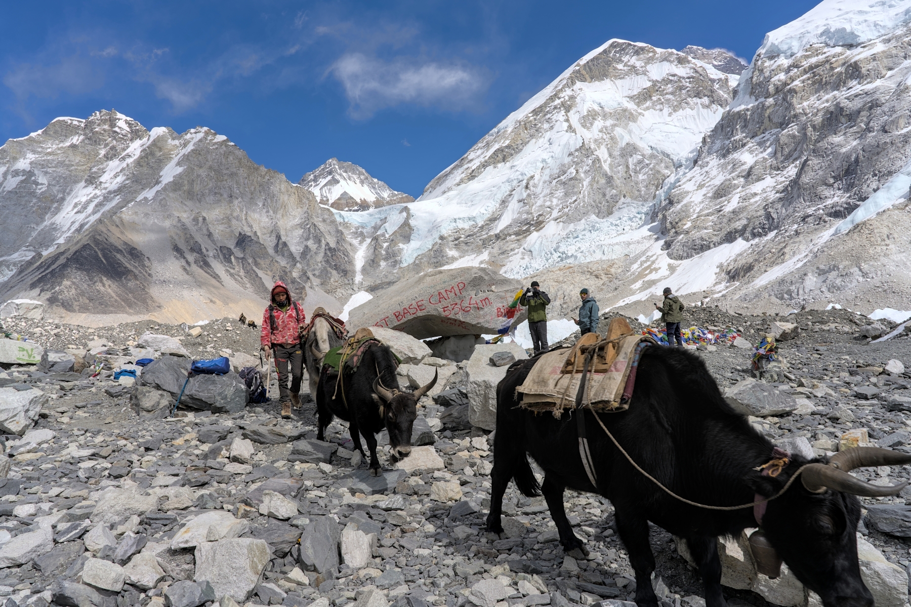
View from EBC. From left: Khumbutse, Changtse, Everest West Shoulder, Mount Everest (barely visible), Nuptse
After a half hour or so at EBC, you’ll head back to Gorak Shep along the same path you took to EBC. The trek back is a bit faster since it is downhill, but none of that will matter. It’s going to take more than hike back to Gorak Shep to wipe the smile off your face. Like, for example, waking up at 3:30AM in the dead of night and heading up a mountain in frigid temperatures. Which is exactly what you will be doing the next day as you climb Kala Patthar!
If the hike from Tingboche to Lobuche is the “most beautiful” of the trek and the hike from Lobuche to EBC is the “most memorable,” the hike up Kala Patthar can be remembered as the “most cold.” The views of sunrise over Mount Everest are special, but make no mistake about it, this hike can be uncomfortable. The trek starts anywhere between 4:00AM and 5:00AM and it will be extremely cold at this time. I mean frigid. When I did this trek in late February, the temperature at 4:00AM was -20 °C (-4 °F), and winds gusts were around 30 mph. Even after dressing as warmly as possible with two pairs of wool socks, two base layers of merino wool, a thermal fleece mid-layer top, fleece pants, down jacket, 2 pairs of gloves, etc., I was still freeing cold when stationary. The weather won’t be quite so bad in May or September (or during the monsoon season for that matter), but the temperature will certainly be below freezing when you start the trek.
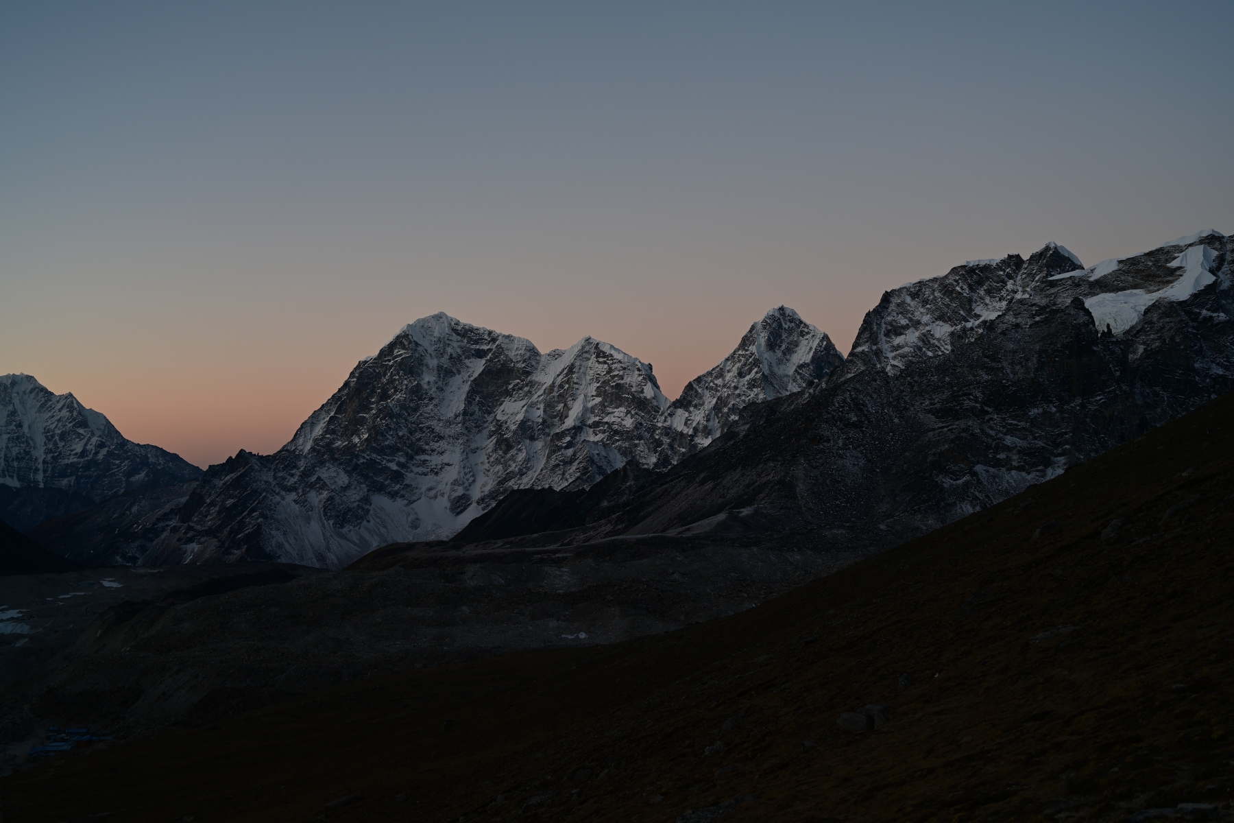
View facing south from Kala Patthar pre-dawn. Gorak Shep at bottom left
The hike up Kala Patthar is purely optional. If you are tired, cold, or just feel like sleeping in, you can. Even if you’re with a group, you can stay behind and wait for the rest of the group to come back from their hike and join them for breakfast. But if you’re feeling up to it, the trek starts by crossing the large, flat plain behind the tea houses (the one with the volleyball court) until reaching big hill on the other side. From there, the trail will snake back and forth up a steep section of hill via switchbacks until crossing over a ridge. From here, the trail will become less steep, but it will still be a steady incline. The higher you walk the colder and windier it will get, and from the top of the ridge it’s at least another 200 meters of vertical elevation gain. The views are better as you get higher, but not that much better, so whether it’s worth it to hike all the way to the top depends on the person. 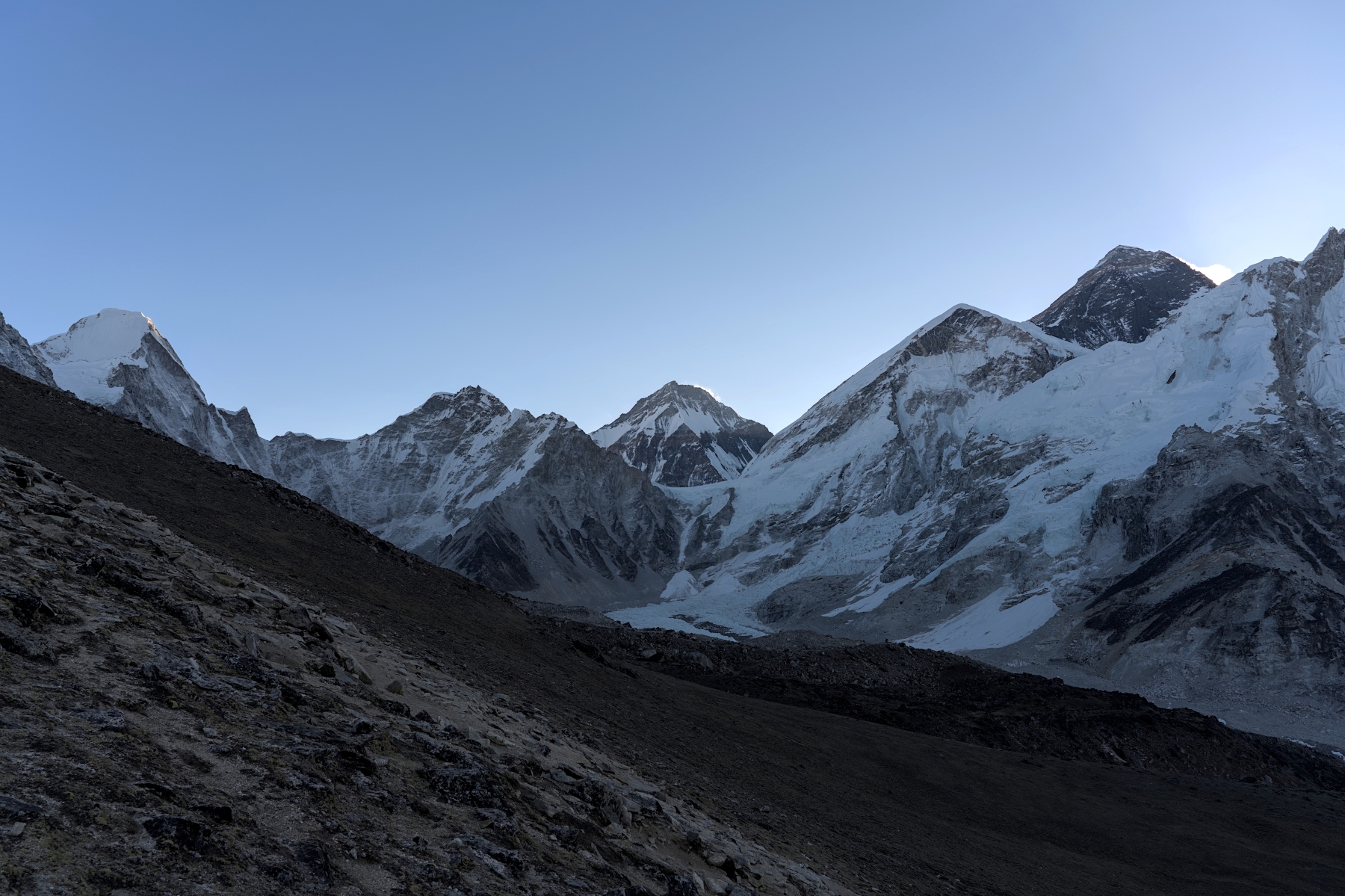
View from halfway up Kala Patthar just before sunrise. Mount Everest is now clearly visible on the right
However high you decide to go, you’ll wait and watch the color of the skies and the mountains change as the sun rises behind Everest. Reds and oranges will turn to purples and pinks, and eventually blues and greens. The mountains to your west (Pumori, Lingtren, and others) will look particularly beautiful during this time as the snow on them lights up in the faint, dawn light. Stay as long as you want (or until you can’t feel your fingers anymore) before heading back down the hill towards Gorak Shep for breakfast.
After breakfast, the trek down the mountain begins, following essentially the exact same route as on the way up. The hike towards Lobuche follows the same route the day before, and the trek to the Thukla pass and down to Thukla is also identical. After Thukla, however, the trek follows a slightly different trail for a bit. Instead of walking the same path along the hillside towards Dingboche, the trek instead heads all the way down to the valley floor. There are three reasons for this: 1) once on the valley floor the trail is easier to hike on, 2) it represents a slight shortcut, and 3) it passes the small settlement of Pheriche that is a possible stopping point for the day.
The first two points are pretty self-explanatory. Hiking along the valley floor presents fewer ups and down and the trail is easier to walk on. And although the shortcut is only 15 minutes at most, there is no need to go back to Dingboche on the way back down the mountain, so why do it? This section of the trek is also neat in its own right, as the mountains that loomed overhead two days earlier look even more impressive from deep in the valley. In addition, by the time you reach Pheriche in mid-afternoon the clouds will have rolled in, and when combined with the brush and grass bespeckling the valley and the quiet stream running through it, will almost feel like you’re hiking through the Scottish Highlands.
Looking north towards Thukla from just outside Pheriche
As for the third reason, being a potential stopping point for the evening, this one requires a bit of explanation. Unlike the trek up to EBC, when hiking back down from EBC the altitude and your fitness levels aren’t much of a concern. Your body will have now spent four nights in a row above 4,400 meters altitude, with the last two being above 4,900 meters. As a result, your body has acclimated to the altitude by producing more red blood cells in order to draw more oxygen from the thinner air. Now that the trek has come back down to 4,400 meters, you have more red blood cells than necessary for this altitude. This makes it feel as if you are hooked up to an oxygen tank, making what might normally be tiring feel like a breeze. By the time you reach Pheriche you will have walked as much as you did the two days prior, but there is a good chance you won’t feel tired and will be ready for more trekking. So many hikers skip the stop at Pheriche and continue hiking down the mountain.
By hiking farther down the mountain, trekkers can lessen the amount of time they will spend hiking the following day. One good reason for doing that is it means more time in Namche Bazar to enjoy food that isn’t dal bhat, have celebratory drinks, play billiards and darts, and even catch some live music. Also, Pheriche is a small settlement that exists only for trekkers (and to an extent yak herders depending on the season) with more basic and more expensive food and accommodation than you’ll find farther down the mountain in Pangboche. Plus, since Pheriche sits at the bottom of a deep valley, it can get surprisingly cold and windy there. My recommendation would be to push on towards Pangboche, but again, the most important thing is to listen to your body. Wherever you decide to stop for the night, you will sleep like a baby with all that lovely oxygen coursing through your veins.
Once you leave the Pheriche Valley, the rest of the hike follows the exact same route it did on the way up the mountain. Hiking the same ridge past Shomare and Pangboche, across the Imja Khola Bridge, and back up the hill a bit to Tengboche. At this point in the morning, the view of the Everest Massif and Ama Dablam should still be clear, so feel free to stop for a couple minutes to enjoy it. The trek then goes back down to the river, then back up, following the same ridge towards Namche Bazar. At this point you will be 2,000 meters lower in elevation than you were a mere 36 hours prior, and will feel like you could run a marathon due to all the oxygen. And you could continue down to Phakding if you really wanted to, sleeping in the same place you did the first night of your trek. Some trekkers do this. But although hiking to Phakding will greatly decrease the trekking distance the following day, I wouldn’t recommend it. Namche Bazar is a really fun town when not acclimatizing, and after your accomplishment you deserve to celebrate. Enjoy yourself!
The final day of the trek heads back down the hill beneath Namche Bazar, over the Hillary Bridge, and along the Dudh Kashi River, past Phakding and onwards to Lukla. It is a long day of hiking in terms of distance, but your body will be a finely-tuned hiking machine at this point. You’ll arrive in Lukla in the late afternoon, spending your last night of the trek at a teahouse waiting for your flight the following morning. This flight is far less scary than the flight here, since you’ll be getting the difficult part out of the way first before enjoying the scenery on your way back to Kathmandu (or Ramechhap), so sleep soundly! As your plane touches down, you’ll grab your bags and head back to your hotel in Kathmandu, camera full of photos and mind full of incredible memories. And you’ll realize that just as Mount Everest is the King of the Mountains, you just completed the King of the Treks.
How Can You Reach Everest Base Camp?
There is hardly any trekker or a common man who wouldn't know about Mount Everest. The charm and grace of Mount Everest sit right at the top. Talking about Everest Base Camp it is one of the toughest yet beautiful trekking journeys.
The items to pack for the trek might differ from person to person and even the trekking agency. Some common items need to be included wherever you are trekking in Nepal, be it Everest Base Camp or Tilicho Lake.
If you are planning to go trek to Everest Base Camp, this thorough set of Everest Base Camp Trek FAQs answers your every question.